NOAA: Hottest April globally while Minnesota shivered

Go Deeper.
Create an account or log in to save stories.
Like this?
Thanks for liking this story! We have added it to a list of your favorite stories.
April 2014 proved once again that global climate and local weather are two very different animals.
The National Oceanic and Atmospheric Administration reports that April tied 2010 for the hottest April on record globally. It also marks the 350th consecutive month of warmer than average temps globally. The last cooler than average month globally was 29 years ago in February, 1985.
Here are the figures from NOAA's National Climatic Data Center.
Turn Up Your Support
MPR News helps you turn down the noise and build shared understanding. Turn up your support for this public resource and keep trusted journalism accessible to all.
The combined average temperature over global land and ocean surfaces for April 2014 tied with 2010 as the highest on record for the month, at 0.77°C (1.39°F) above the 20th century average of 13.7°C (56.7°F).
The combined global land and ocean average surface temperature for the January–April period (year-to-date) was 0.64°C (1.15°F) above the 20th century average of 12.6°C (54.8°F), the sixth warmest such period on record.
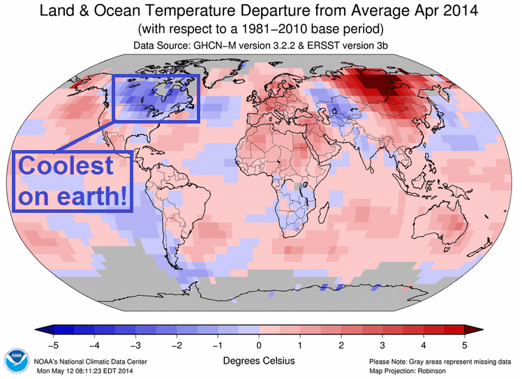
Ironically, Minnesota and the Upper Midwest were among the coolest spots on the planet last month. Temperatures in the Twin Cities ran 4.8 degrees below average last month.

So far 2014 is the sixth warmest year on record globally. Again, the Upper Midwest and southern Canada are among the coldest places on earth so far this year. This winter's polar vortex produced a frigid start, and temperatures have had a tough time recovering this spring.

Interestingly, our stuck jet stream this year has produced unusually mild weather in places like Alaska and Russia.
Here's NOAA's global highlights map from April.

El Nino may boost 2014 temps even higher
Globally the sixth warmest year on record so far may get a boost from a developing El Nino later this summer.

NOAA and the Australian Bureau of Meteorology put the chances of a developing El Nino at 65 percent and 70 percent respectively. Some see a so-called "Super El Nino" kicking in this summer.
If that happens, global temps may get a boost in the second half of 2014, and that could bump the ranking for 2014 into the top 5 warmest years on record.
Hers the latest El Nino Alert from the Australian Bureau of Meteorology.
Tropical Pacific Ocean edges further toward El Niño
Issued on Tuesday 20 May 2014 | Product Code IDCKGEWWOO
The tropical Pacific Ocean continues a general trend toward El Niño, with just over half of the climate models surveyed by the Bureau suggesting El Niño thresholds will be exceeded by August. An El Niño ALERT remains in place, indicating at least a 70% chance of an El Niño developing in 2014.
The tropical Pacific Ocean surface has warmed steadily since February, with sea surface temperature anomalies increasing by 0.5 to 1.0 °C. For El Niño to be established and maintained, the sea surface needs to warm further, and be accompanied by a persistent weakening of the trade winds and a consistent increase in cloudiness near the Date Line. In the past fortnight, trade winds have generally been near normal, though have weakened once again in recent days.
El Niño has impacts on many parts of the world, for example, below-average rainfall in the western Pacific and Indonesian regions and increased rainfall in the central and eastern Pacific. For Australia, El Niño is usually associated with below-average rainfall over southern and eastern inland Australia, with about two thirds of El Niño events since 1900 causing major drought over large parts of the continent.
Here's a look at NOAA's suite of model predictions for tropical pacific Sea Surface Temps (SST's) later this year.
If a strong or so called "Super El Nino" develops quickly later this summer, global temps may spike higher and another top five warmest year globally may be in the cards. Some climate watchers acknowledge the possibility that 2014 may eventually challenge for one of the top spots as the warmest year on record.
Stay tuned.


