Epic flood threat and severe risk continue

Go Deeper.
Create an account or log in to save stories.
Like this?
Thanks for liking this story! We have added it to a list of your favorite stories.
This may be the stormiest week of the year in Minnesota. At least we better hope so.
There's simply no margin for error now across a good chunk of Minnesota. With so many rivers and lakes overflowing, farm fields under water, basements at risk of inundation there's simply no where else for additional water to go without causing major problems.

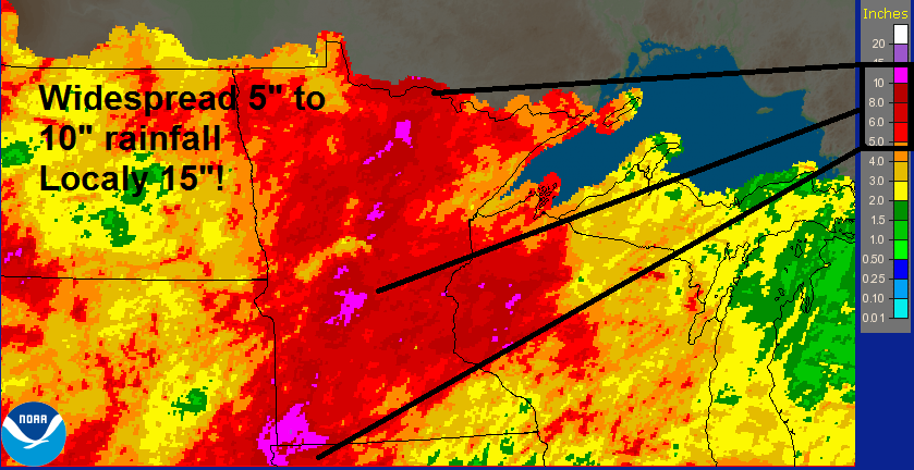
One look at the rainfall map over Minnesota the past 30 days shows you why we're at capacity, even record water levels on many Minnesota lakes and rivers. Rainfall totals of 10 to 15 inches is literally half a year's rain in the past 30 days across a big swath of Minnesota.
Turn Up Your Support
MPR News helps you turn down the noise and build shared understanding. Turn up your support for this public resource and keep trusted journalism accessible to all.
The heaviest flood zone runs in a swath from southwest Minnesota to International Falls.

20.58 inches precipitation so far in 2014 at Minneapolis-St. Paul International Airport (second wettest year on record to date)
+8.81 inches vs. average so far
Stormy Monday
Monday afternoon and evening continued our recent streak of severe outbreaks. The target for our latest Mesoscale Convective System? The Interstate 90 corridor in southern Minnesota.
Here's Monday's radar loop tracking a classic storm cluster that dumped widespread 3 inch rainfall totals and cranked out winds between 60 to 96 miles per hour in a swath from Sioux Falls, South Dakota to Rochester, Minnesota, and beyond.

The list of damage reports is too extensive to print in this post, but the Interstate 90 corridor got blasted with wind damage and flooding. At one point extensive street flooding was occurring in several towns in southern Minnesota, including Fairmont, St. James, Vernon Center and Waseca.
A total of 30 preliminary tornado reports came in, but thankfully none in Minnesota. At least we got lucky on that one.
Here's the map of Monday's storm reports from the National Oceanic and Atmospheric Administration.

Flood warnings continue for most of southwest Minnesota. Many roads were and still are impassable in Pipestone and Rock counties due to extensive flooding.
Severe risk again today and Wednesday
The atmosphere over Minnesota remains juiced today for another round of storms. The surface and upper level dynamics may not be as impressive as Monday, but with temps in the upper 80s and dew points rising into the sticky 60s it won't take much to get a few big storms rolling if they are able to blow late this afternoon and evening.
Once again the biggest severe risk centers on the I-90 corridor in southern Minnesota.
Here's today's slight risk zone from NOAA's Storm Prediction Center. Look familiar?

Here's another look at the severe threat from the La Crosse, Wisconsin, National Weather Service in today's video briefing.
The severe party continues Wednesday as the next low pressure wave rolls in with another shot of potentially heavy storms. Here's NOAA's risk zone for Wednesday.

Storm coverage may be a little more spotty today and early Wednesday. By Wednesday night and Thursday, the next low rides in, and that may trigger more widespread thunderstorms coverage with both heavy rain and severe potential.

Here's a look at metro rainfall totals for the next few days. Another 1 to 2 inches seems reasonable tonight and Wednesday night.

Much of southern Minnesota could log a few more (unwelcome) inches by Friday. Keep in mind, summer convective thunderstorms are very localized in nature. You may get an inch and the guy a mile down the road could get four.

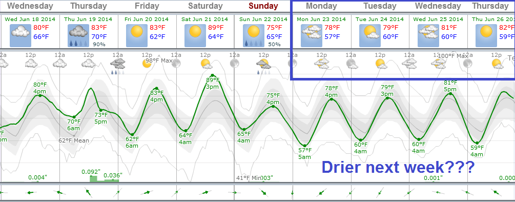
Light at the end of the tunnel?
There are some signs we may finally begin to dry out next week as the jet stream lifts mercifully north into Canada and a bubble of drier protective drier high pressure builds in over the Upper Midwest.
Here's NOAA's Global Forecast System surface map for next Tuesday.

The GFS and the European Centre for Medium-Range Weather Forecasts are optimistic for mostly dry weather next week.

If we can get through the rest of this week without any more major multi-inch rains, our lakes and rivers could begin to respond by backing off a little bit next week, and submerged fields could begin to dry out.
Stay tuned.


