Classic summer weekend: steamy sun, occasional thunder
Go Deeper.
Create an account or log in to save stories.
Like this?
Thanks for liking this story! We have added it to a list of your favorite stories.
How do you know it's a summer weekend in Minnesota? The radar glows with vibrant colors, while thunder, your weather radio and your rain-filled downspouts make strange musical weather noises.
Get ready for a mixed bag weekend that should feature a little something for everyone.
Some warm sunny hours? Check. Steamy tropical dew points approaching the 70 degree mark? Roger that. Occasional thunderstorms and a slight risk for severe storms from the National Oceanic and Atmospheric Administration? Yep.
In other words, a pretty typical Minnesota summer weekend.
Turn Up Your Support
MPR News helps you turn down the noise and build shared understanding. Turn up your support for this public resource and keep trusted journalism accessible to all.
.93 inch model average rainfall output for the metro this weekend
1.26 inches Twin Cities National Weather Service forecast rainfall output this weekend for Minneapolis-St. Paul International Airport

Occasional rain and thunder
Here comes our next low pressure wave with a cargo of scattered storms, just in time for another weekend!

We'll see quite a few dry, sunny summery hours this weekend but scattered strong to severe storms will rumble at times.
The highest chances for strong storms appear to favor Saturday afternoon and evening, with another shot possibly blowing up late Sunday as the cool front pushes through.
There is a slight risk for severe storms packing high winds and hail both Saturday and Sunday across Minnesota. The highest risk for strong to severe storms? Saturday afternoon and evening.


Some potentially good news?
Rainfall totals may not be as high as it appeared they might be earlier this week for the metro. Most scenarios favor an inch or two of rain for the metro this weekend.
That's a far better outcome than the possible 3 to 4 inch totals projected earlier this week for a major metro area with already overflowing river systems.
There's still a chance we could see some isolated heavier metro totals this weekend, but the trends are encouraging.

The heaviest rainfall totals may fall in the eastern Dakotas and western Minnesota this weekend. Flash flood watches are flying out west.

Rivers falling
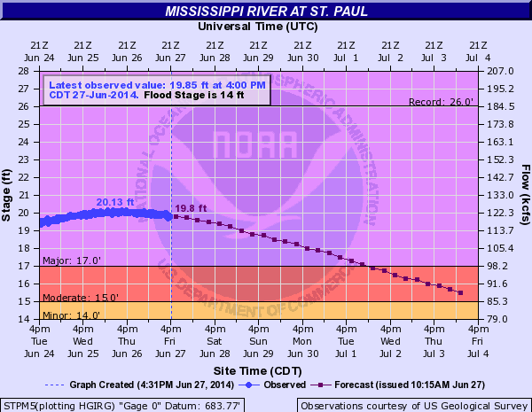
The record summer crests are slowly fading now. The Crow River in Delano is down about 2 feet from Tuesday's crest!

The Mississippi in St. Paul is slowly backing off from Thursday's high water mark.

The wet weekends of summer 2014
Can we work on that whole weekend weather timing thing by the way? Take a look at weekend rainfall totals since the start of June.
May 31-June 1 (3.02 inches)
June 6-7 (.89 inch)
June 14-15 (2.24 inches)
June 21-22 (4.13 inches, includes Thursday June 19 deluge)
June 28-29 ??
Yes, 2014 is the wettest on record so far. Check out the spike -- the off-the-charts bar on the right is the polar/hydro vortex year that is 2014.

Next week: drying out
Next week looks much drier and more comfy. Sunshine, temps in the 70s and dew points in the comfy 50s will be good tonic for soggy Minnesota farm fields and swollen rivers and lakes.

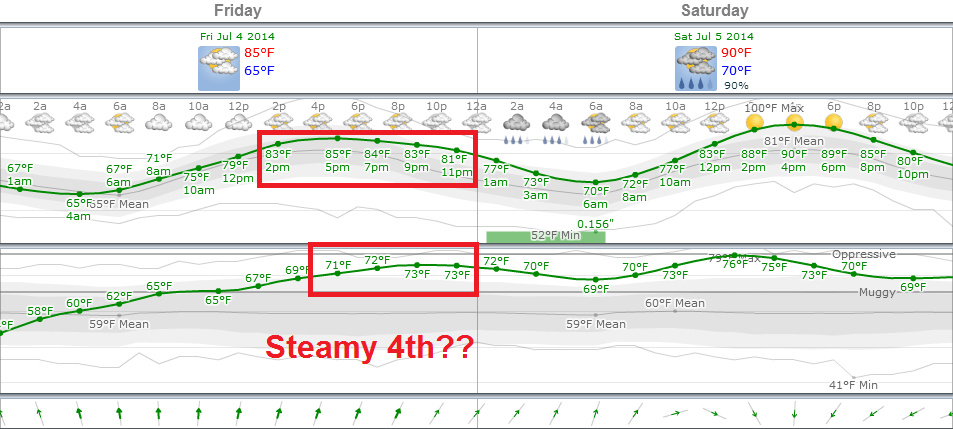
Fourth of July preview: Partly sweaty with a chance of rain
The one sure thing on the Fourth of July? Parades, ice cream and celebration. The early look at the forecast looks mixed. A high in the 80s looks likely, with at least a chance of some scattered thunderstorms mixed in with sunny, steamy hours.

I'll be away enjoying some of our fine Minnesota weather the next week. Have a great holiday week!


