AM thunder, PM sauna, heat advisory issued

Go Deeper.
Create an account or log in to save stories.
Like this?
Thanks for liking this story! We have added it to a list of your favorite stories.
One of the beauties of tracking weather systems is that until they develop they're like Forrest Gump's proverbial box of chocolates.
You never know what you're gonna get.
Case in point, late August warm fronts in Minnesota. They often bubble north at night, and fire so called "nocturnal" thunderstorms. These storms like to develop as the nights get longer. The upper atmosphere has more time to cool off after our earlier late August sunsets. Advancing warm air near ground level cuts underneath cooler air above, increasing instability.
The result? Nature's alarm clock can go off as we hit sunrise in late August. Our early AM T-storm batch arrived on schedule with varied rainfall totals. The north metro saw totals near 1", with far less as storms faded central and south. Here are some early preliminary totals.
Turn Up Your Support
MPR News helps you turn down the noise and build shared understanding. Turn up your support for this public resource and keep trusted journalism accessible to all.
MSP Airprt .03"
Lakeville .04"
St. Paul .06"
Eden Prairie .11"
Crystal .87"
Blaine .92"
Mankato 1.34"
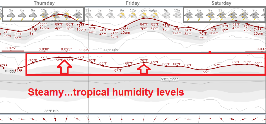
Now the steamy tropical air mass takes over this afternoon. The Twin Cities NWS has posted a heat advisory from noon until 8pm tonight.

State Fair opening day: Rain gear required?
Weather as the featured opening act at the 2014 Minnesota State Fair? Right on cue. We should have seen this one coming in the crazy weather year of 2014.
Think about it for a moment. Weather, and our Minnesota climate is at the essence of the Fair. We are a thriving agricultural state because of a (usually) favorable climate. Our forests historically thrive, and we benefit from those vast resources. Throw in 10,000 lakes and excellent four-season recreational opportunities and tourism and you have a winner. Minnesota's weather and climate have allowed us to take home the big prizes from the Weather Midway.
Prosperity. Quality of life.
Here's a close up look at the opening days of the 2014 fair, with a steamy tropical air mass in place and occasional thunderstorm chances. Friday may be shaping up as the best time for an early dry State Fair excursion.

Climate Cast: Live at the Fair 9 a.m. Thursday
One of the great things about working for a major market media organization is the time we spend at the Minnesota State Fair.

I hope you can swing by the MPR Booth at the corner of Judson and Nelson to say hello Thursday morning. Kerri Miller and I will visit with University of St. Thomas professor and climate change expert John Abraham for a special one hour Climate Cast live from the Fair.
Among our possible topics Thursday:
2014 is the 3rd warmest year globally, but not in Minnesota. What the latest from NOAA, and why is Minnesota among the coldest places on earth relative to average this year?
Dark Snow Project: How soot from fires is accelerating Arctic snow and ice melt.
Western drought, fires and "feedback loops." How is climate change in the North American West triggering wider changes?
Have we changed the jet stream?
Hidden adaptation taxes: How Minnesotans are all paying for climate changes now, and in the future.
Twin Cities Urban Heat Island: We're number 9?
Yes, Minnesota lands on top 10 lists for quality of life, longevity, livability and many other desirable categories. Why not for urban heat islands?
Here's an interesting piece of work from on Urban Heat Islands from Climate Central. They studied 60 U.S. cities and found the Twin Cities lands at number 9 for the biggest urban heat island effects. The yearly average temperature in the inner metro core is about 4.3 degree more than. the surrounding countryside in summer. The differences are even great in winter and at night.
It's not you imagination, it does feel warmer in the city.

Here are some highlights from the study.
Our analysis of summer temperatures in 60 of the largest U.S. cities found that:
57 cities had measurable urban heat island effects over the past 10 years. Single-day urban temperatures in some metro areas were as much as 27°F higher than the surrounding rural areas, and on average across all 60 cities, the maximum single-day temperature difference was 17.5°F.
Cities have many more searing hot days each year. Since 2004, 12 cities averaged at least 20 more days a year above 90°F than nearby rural areas. The 60 cities analyzed averaged at least 8 more days over 90°F each summer compared to adjacent rural areas.
In two thirds of the cities analyzed (41 of 60), urbanization and climate change appear to be combining to increase summer heat faster than climate change alone is raising regional temperatures. In three quarters (45 of 60) of cities examined, urbanized areas are warming faster than adjacent rural locations.
The top 10 cities with the most intense summer urban heat islands (average daily urban-rural temperature differences) over the past 10 years are:
Las Vegas (7.3°F)
Albuquerque (5.9°F
Denver (4.9°F)
Portland (4.8°F)
Louisville (4.8°F)
Washington, D.C. (4.7°F)
Kansas City (4.6°F)
Columbus (4.4°F)
Minneapolis (4.3°F)
Seattle (4.1°F)
On average across all 60 cities, urban summer temperatures were 2.4°F hotter than rural temperatures.
Urban heat islands are even more intense at night. Over the past 10 years, average summer overnight temperatures were more than 4°F hotter in cities than surrounding rural areas.
Growing chances for Hurricane Cristobal
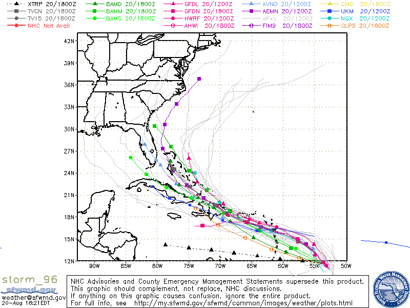
The National Oceanic and Atmospheric Administration's National Hurricane Center is paying close attention to what could become Hurricane Cristobal in the coming days. Hurricane forecasters in Miami have upped the chances for developing a named storm to 60 percent. Hurricane Hunter aircraft will fly into the developing system Thursday.


As is often the case days in advance, potential storm tracks have shifted all over the place. The latest trends are an eastward shift away from the Gulf of Mexico toward the Atlantic.
The reality? Anywhere from the Gulf through Florida to the Eastern Seaboard are potentially at risk late next week.

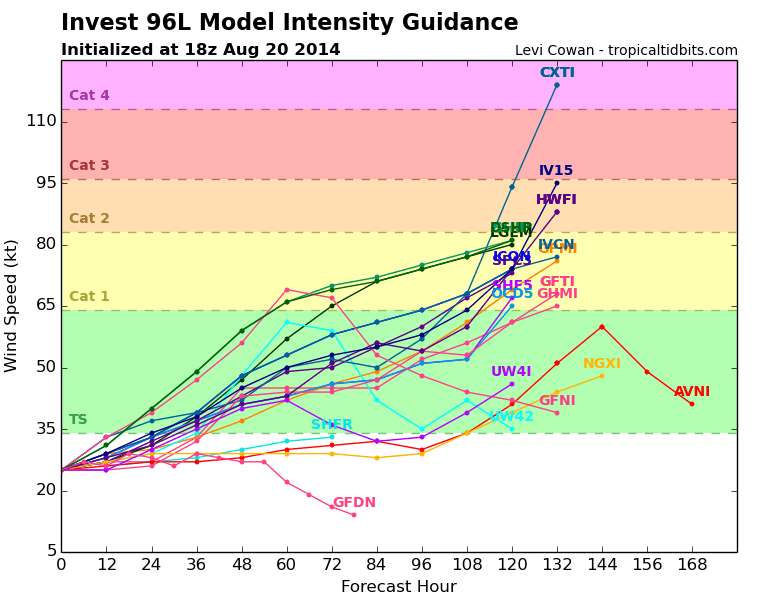
The most difficult prediction in hurricane remains intensity fluctuations. Various models spit out anything from a tropical storm, to a major hurricane in the next week.

Stay tuned.


