Arctic cold front brings dangerously low temps and wind chills
Go Deeper.
Create an account or log in to save stories.
Like this?
Thanks for liking this story! We have added it to a list of your favorite stories.
This is way colder than your typical cold front. The polar vortex has shifted, sending an incredible combo of very low temps and wind chills to the Upper Midwest.
A quick explanation of the polar vortex:
We're now in extremely cold arctic air that surged southward due to a bulge in the polar vortex circulation.
How cold?
Turn Up Your Support
MPR News helps you turn down the noise and build shared understanding. Turn up your support for this public resource and keep trusted journalism accessible to all.
Lows on Wednesday morning are expected to reach the 30s below zero across Minnesota and parts of western Wisconsin:

International Falls could drop into minus 40s.
The Twin Cities metro area would get close to the record low of minus 30, with lows expected to hit at least 27 below zero.
We haven't set a record low temp in the Twin Cities metro area during the month of January since 1977. The last time that we hit minus 30 or lower in the metro was Feb. 2, 1996, at 32 below.
Wind chill warnings continue for all of Minnesota and western Wisconsin Tuesday night through Wednesday night, ending at 9 a.m. Thursday.
Wind chills of minus 35 to 65 are expected through the period. Exposed skin can get frostbite in as little as 5 minutes when the wind chill is 50 below, and Twin Cities metro area wind chills are expected to be minus 50 or lower from Tuesday evening through early Wednesday morning, then in the 40s below zero the remainder of Wednesday into early Thursday.
Here are wind chill projections for several locations:

The Twin Cities metro area wind chill plot is indicated by the dark blue line.
The Duluth NWS office had this post:

"Tonight" refers to Tuesday night.
Wednesday highs will be in the teens below zero in most areas, with 20s below in northwestern Minnesota:

You can check the latest forecasts and warnings from the NWS offices in the Twin Cities, Grand Forks, N.D., Sioux Falls, S.D., La Crosse, Wis and Duluth.
As always, updated weather information can be heard on the Minnesota Public Radio Network, and you’ll also see updated weather info on the MPR News live weather blog.
There will be much less wind Wednesday night, and radiative cooling will allow temps to dip to the 30s below zero and 20s below zero:

Thursday highs are expected to reach the single digits below zero across most of Minnesota.
Then it gets better.
Twin Cities metro area highs reach the mid-teens above zero on Friday, and forecast models still show a high in the upper 30s on Saturday, followed by middle 30s on Sunday.
Hypothermia and frostbite
Thankfully, this combination of extremely cold temperatures and wind chills is rare.
The NWS and Ramsey county have posted some excellent information on cold weather safety.
It's good to know the symptoms of frostbite and hypothermia:

Covering exposed skin and limiting our time outdoors are key during this extreme cold.
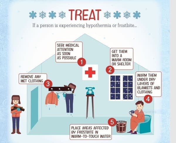
Treatment tips for frostbite or hypothermia:

Next chance of snow?
As the cold air slides eastward, there could be enough moisture for some light snow Thursday and Thursday night.
The National Oceanic and Atmospheric Administration’s North American Mesoscale forecast model shows the potential snow pattern from Thursday and Thursday evening:

Coldest wind chills?
The Minnesota State Climatology Office has answers to your questions about Minnesota's coldest wind chills:
What is the coldest windchill ever seen in the Twin Cities or Minnesota? The answer can be a little tricky because on November 2001 the formula on how to calculate the windchill was changed. Perhaps the coldest windchill the Twin Cities has ever seen was -67 degrees F with the new formula (-87 degrees F with the old formula) back on January 22nd 1936. The temperature was -34 degrees F with a wind speed of 20mph. All traffic in the Twin Cities was severely hampered and a number of fatalities were caused by the cold. Without a lengthy state-wide wind record, it is difficult to say when the lowest statewide windchill temperature was observed. There are some candidate dates though besides January 22, 1936. On January 9th and 10th, 1982 temperatures of -30 degrees F and winds of around 40mph were reported in Northern Minnesota. This would translate to -71 degrees F by the new formula (-100 degrees F by the old formula.)
Those are impressive numbers!


