Snow gradually tapers off Tuesday; 4th snowiest February on record
Go Deeper.
Create an account or log in to save stories.
Like this?
Thanks for liking this story! We have added it to a list of your favorite stories.
Our latest snow event is performing admirably again.
Snowfall totals from 3 to 6 inches cover most of eastern Minnesota Tuesday. Higher totals are piling up in Wisconsin as expected. The snow will gradually taper off from west to east Tuesday afternoon across the region.
Most areas will pick up another 1 to 3 inches Tuesday. Longer duration brings higher totals into Wisconsin as you head east.

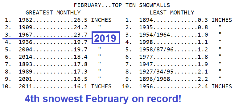
4th snowiest February
Turn Up Your Support
MPR News helps you turn down the noise and build shared understanding. Turn up your support for this public resource and keep trusted journalism accessible to all.
Minneapolis-St. Paul International Airport has already logged at least 3.7 inches of new snowfall with this system. That puts our February snowfall total over 20 inches, which is good enough for the fourth snowiest February on record in the Twin Cities.

Catching a break
The weather maps suggest this may be the last significant snow we see for a while.
Thursday's potential snowmaker looks light. There may be some light snow Sunday, but overall snowfall looks minor after Tuesday for the next week.
Temperatures remain cooler than average for the next week overall.

Stay safe out there today.
Chicago ice storm
It could always be worse. Chicago and northern Illinois are dealing with a full-blown ice storm.


