How cold will it be?; European model gives us mild temps next weekend
Go Deeper.
Create an account or log in to save stories.
Like this?
Thanks for liking this story! We have added it to a list of your favorite stories.
Let's start with a warm thought.
The European forecast model shows a high of 32 degrees in the Twin Cities one week from today:

The European model uses Celsius degrees, so a temp of zero in their model is equal to 32 degrees Fahrenheit. You'll also notice a similar high temp the following Monday. Dates are day/month/year, so 09/03/2019 is March 9.
Temperature trends
Turn Up Your Support
MPR News helps you turn down the noise and build shared understanding. Turn up your support for this public resource and keep trusted journalism accessible to all.
Our high temps today are expected to reach the teens across most of Minnesota and western Wisconsin, with some single digits in north-central and northwestern Minnesota.
Lows late Saturday night/early Sunday morning reach the teens below zero in most areas:

A few spots in northwestern and north-central Minnesota could dip into the 20s below zero.
A wind chill warning starts at 9 p.m. Saturday in northwestern Minnesota and runs through Sunday morning. Wind chills could drop to -40 in the warning area.
West-central Minnesota has a wind chill warning from midnight Saturday night through Sunday morning, and the remainder of Minnesota plus western Wisconsin have a wind chill advisory for that same period:

Details of the wind chill warnings and advisories:
URGENT - WINTER WEATHER MESSAGE
National Weather Service Twin Cities/Chanhassen MN
311 AM CST Sat Mar 2 2019
...DANGEROUSLY COLD WIND CHILLS SATURDAY NIGHT THROUGH SUNDAY
MORNING...
.Dangerous wind chills of -25 to -40 are expected Saturday night
through Sunday morning as Arctic air invades the region. The
coldest wind chills are expect over west central Minnesota,
generally west of a Motley to St Cloud to New Ulm line, where a
Wind Chill Warning has been issued. East of that line, including
the Mankato, Twin Cities, and Eau Claire areas, a Wind Chill
Advisory has been issued.
Frostbite and hypothermia can occur if precautions are not taken.
Make sure you wear a hat and gloves.
MNZ043>045-050>053-059>063-066>070-075>078-082>085-091>093-
WIZ014>016-023>028-021715-
/O.NEW.KMPX.WC.Y.0010.190303T0600Z-190303T1800Z/
Morrison-Mille Lacs-Kanabec-Benton-Sherburne-Isanti-Chisago-
Wright-Hennepin-Anoka-Ramsey-Washington-McLeod-Sibley-Carver-
Scott-Dakota-Nicollet-Le Sueur-Rice-Goodhue-Watonwan-Blue Earth-
Waseca-Steele-Martin-Faribault-Freeborn-Polk-Barron-Rusk-
St. Croix-Pierce-Dunn-Pepin-Chippewa-Eau Claire-
Including the cities of Little Falls, Princeton, Mora, Foley,
Elk River, Cambridge, Center City, Monticello, Minneapolis,
Blaine, St Paul, Stillwater, Hutchinson, Gaylord, Chaska,
Shakopee, Hastings, St Peter, Le Sueur, Faribault, Red Wing,
St James, Mankato, Waseca, Owatonna, Fairmont, Blue Earth,
Albert Lea, Osceola, Rice Lake, Ladysmith, Hudson, River Falls,
Prescott, Menomonie, Durand, Chippewa Falls, and Eau Claire
311 AM CST Sat Mar 2 2019
...WIND CHILL ADVISORY IN EFFECT FROM MIDNIGHT TONIGHT TO NOON
CST SUNDAY...
* WHAT...Very cold wind chills expected. Wind chills as low as
25 to 35 below zero expected.
* WHERE...Portions of northwest and west central Wisconsin and
central, east central, south central and southeast Minnesota.
* WHEN...From midnight tonight to noon CST Sunday.
* ADDITIONAL DETAILS...The dangerously cold wind chills could
cause frostbite on exposed skin in as little as 10 minutes.
PRECAUTIONARY/PREPAREDNESS ACTIONS...
A Wind Chill Advisory means that cold air and the wind will
combine to create low wind chills. Frostbite and hypothermia can
occur if precautions are not taken. Make sure you wear a hat and
gloves.
As always, updated weather information can be heard on the Minnesota Public Radio Network, and you’ll also see updated weather info on the MPR News live weather blog.
You can check the latest forecasts from the NWS offices in the Twin Cities, Grand Forks, N.D., Sioux Falls, S.D., La Crosse, Wis., and Duluth.
Sunday highs stay below zero in much of western Minnesota, and creep slightly above zero in the east:

High temps will also be very cold on Monday:

These are very cold temps for early March; our average high this time of year is 35 degrees in the Twin Cities metro area.
Twin Cities metro area highs are expected to reach around 15 Tuesday, followed by 20 on Wednesday and lower 20s Thursday.
Friday snow totals
The Friday snow total at Minneapolis-St. Paul International Airport was 5.6 inches. Our 2018-2019 snow season total is now 62.4 inches in the Twin Cities, which is 20 inches above normal for this point in the snow season.
There were a lot of snow totals in the 4 to 5.5 inch range around the metro area on Friday. There was even a 6.5 inch snow report in Maple Grove. St. Cloud tallied around 4 inches, Rochester reported 3 inches.
A snapshot of Friday's snow totals looks like this:

You can check snow accumulations as they are posted by the National Weather Service. Hover over a location on the National Weather Service snow map site to see the snow total and the time of observation.
Light snow chance on Monday
Minnesota and western Wisconsin will have a chance of patchy flurries Saturday afternoon and evening.
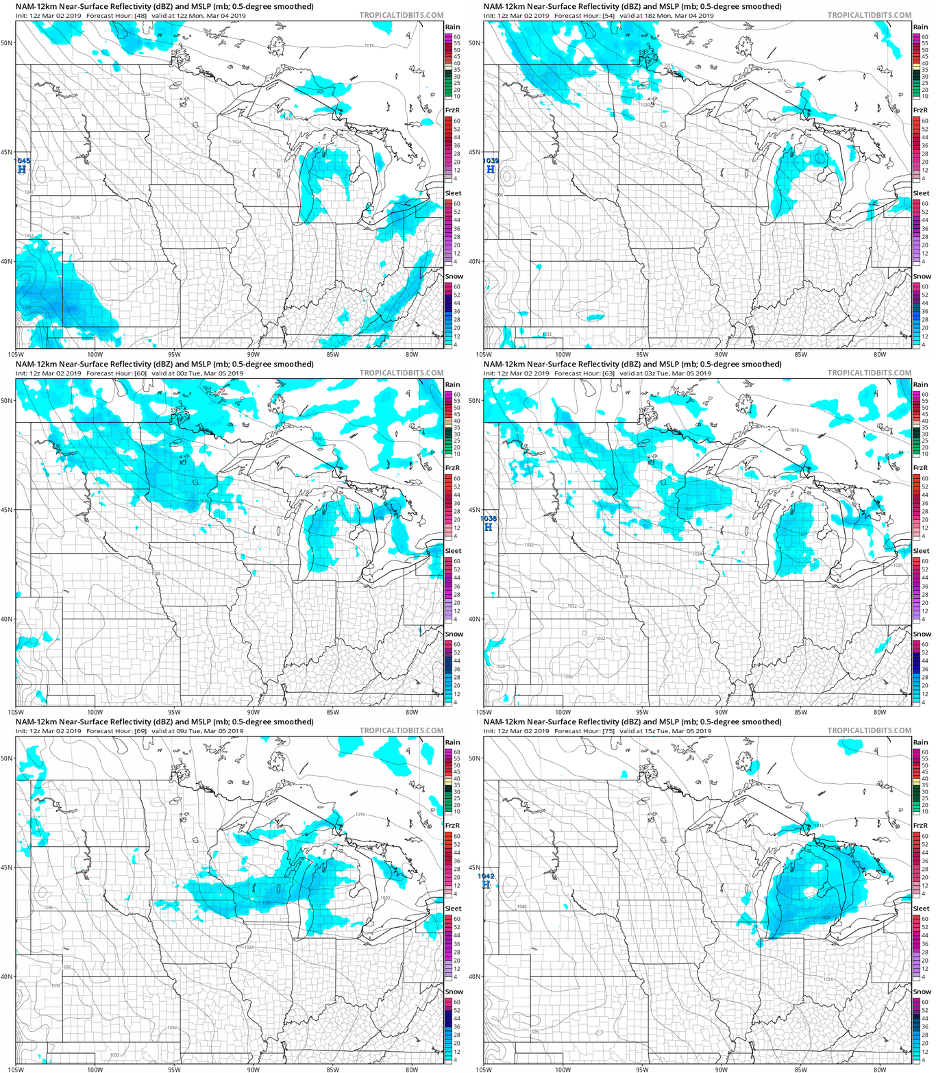
Looking ahead, there will be a chance of light snow showers Monday and Monday evening.
The National Oceanic and Atmospheric Administration’s North American Mesoscale forecast model shows the potential snow pattern for Monday through Monday night:

Accumulations should be light in areas that do see some snow.
Programming note
You can hear my live weather updates on Minnesota Public Radio at 7:49 a.m. Thursdays and Fridays, and at 7:35 a.m., 9:35 a.m. and 4:35 p.m. each Saturday and Sunday.


