Great weather to start the Minnesota State Fair. How rare are 90s at the fair?
Thunderstorm chances return on Sunday

Go Deeper.
Create an account or log in to save stories.
Like this?
Thanks for liking this story! We have added it to a list of your favorite stories.
There isn’t any steamy weather in sight, despite the fact that the Minnesota State Fair started Thursday. I don’t see any 90s during the first seven days.
Temperature trends
Thursday afternoon highs will be in the 70s across much of Minnesota and west-central Wisconsin. Parts of north-central and northeastern Minnesota and far northwestern Wisconsin will see 60s.
Friday afternoon highs will be mainly in the 70s:

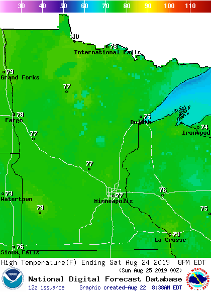
Saturday will feature mostly 70s:
Turn Up Your Support
MPR News helps you turn down the noise and build shared understanding. Turn up your support for this public resource and keep trusted journalism accessible to all.

Sunday will bring us highs in the 70s, with some patchy 60s in the north:

The Twin Cities metro area highs are projected to reach the low to mid-70s Monday through Wednesday of next week.
Rain could return late in the weekend
Thursday and Friday look dry across most of Minnesota and western Wisconsin. Far western Minnesota could see scattered showers and thunderstorms late Saturday afternoon and Saturday evening.
That shower and thunderstorm chance spreads into eastern Minnesota and western Wisconsin overnight Saturday night. We could all see some off and on showers and thunderstorms Sunday into Monday.
The National Oceanic and Atmospheric Administration’s Global Forecast System model shows the potential precipitation pattern Saturday evening through Monday evening:

As always, updated weather information can be heard on the Minnesota Public Radio Network, and you’ll also see updated weather info on the MPR News live weather blog.
State Fair weather
The Minnesota State Climatology Office has compiled detailed info about our official Twin Cities temps and rainfall during past Minnesota State Fairs.
We have not hit 90 degrees or warmer in the Twin Cities during the Minnesota State Fair since 2013. Here are some State Fair temperature highlights, from the Climatology Office:
Although a wide variety of weather has greeted fairgoers over the years, it's the late-summer heat waves that are perhaps most memorable.
By far the highest temperature in the Fair's history was 104 degrees Fahrenheit on Sept. 10, 1931. In fact, the second-highest temperature ever recorded during the Fair was 99 degrees Fahrenheit, notched the same year but two days earlier.
Not surprisingly, the 1931 Fair is the current record-holder for high temperatures, averaging 92.6 degrees Fahrenheit, which is 2.7 degrees Fahrenheit higher than the runner-up (1922). It is worth noting that the 1931 Fair ran eight days, from Sept. 5-12, whereas the Fair currently runs 12 days, making it less likely to sustain such high temperatures over that longer period.
On the other hand, 1931's record is even more impressive considering that the entire Fair took place during September, when extremes of heat become increasing rare.
Recent steamy State Fair conditions were experienced during 2013, which was the third warmest on record and also had a record six days with 90-degree high temperatures. 2012 was quite warm as well, with an average daily maximum temperature of 87.1 degrees. The last five State Fairs, however (2014 through 2018), generally have lacked hot weather, with no 90-degree high temperatures recorded in any of those years.
The coolest Minnesota State Fair was during the six-day run of the Fair from Sept. 5-10 1898 with an average maximum temperature of 64.2 degrees. The coldest maximum temperature for the Fair is 52 degrees on Sept. 7, 1911, and the coldest minimum temperature is 33 degrees on Sept. 13, 1890. The coolest Fair morning in recent years was a chilly 36 degrees on Sept. 1, 1974.
Programming note
You can hear my live weather updates on Minnesota Public Radio at 7:49 a.m. Thursdays and Fridays, and at 7:35 a.m., 9:35 a.m. and 4:35 p.m. each Saturday and Sunday.


