Hurricane Dorian to Category 4? Forecast tracks still uncertain
Latest forecast models show growing destructive landfall potential

Go Deeper.
Create an account or log in to save stories.
Like this?
Thanks for liking this story! We have added it to a list of your favorite stories.
Hurricane Dorian is poised to become a major hurricane. The latest forecast models suggest Dorian is increasingly likely threaten the Florida coast around Labor Day.
Forecast track uncertainty remains high
Dorian has already surprised forecast models as it largely skirted east of Puerto Rico Wednesday. Thursday’s model runs still show a high degree of variability in the forecast path of Dorian.

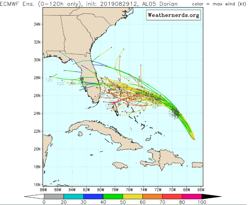
Recent forecast tracks and intensity trends for Hurricane Dorian have produced some potentially ominous outcomes for Florida. Many models including the highly respected the European model still suggest a potentially devastating Florida Landfall early next week.
The latest official track from the National Hurricane Center still favors a major hurricane Florida landfall on Labor Day.
Turn Up Your Support
MPR News helps you turn down the noise and build shared understanding. Turn up your support for this public resource and keep trusted journalism accessible to all.

European model: Slower and further south
One interesting model trend Thursday is the European model. It’s been consistently on the left side of the guidance envelope. The latest model ensembles favor a slower storm that could make landfall further south on the east coast of Florida. That scenario would potentially bring much higher real estate value north of Miami into play.

Category 4?
The latest National Hurricane Center intensity forecast for Dorian projects a Category 4 hurricane with 130 mph winds by Sunday. Dorian is a compact storm. It’s travelling over warm, open water and through a favorable low wind shear environment for the next couple of days. That will allow Dorian to intensify.

Here’s the forecast intensity discussion from NOAA’s National Hurricane Center:
The new intensity forecast is unchanged from the previous one. Dorian will be moving through a favorable environment of low vertical wind shear and warm sea surface temperatures. This should allow for at least steady intensification, and Dorian is forecast to become major hurricane on Friday. Dorian is predicted to remain a dangerous hurricane throughout the remainder of the forecast period. The NHC intensity forecast is again near the upper end of the guidance in best agreement with the HWRF and FSSE models.
Minnesota: Mostly great Labor Day weekend
Back home our late summer weather winning streak continues. High pressure will generally bring sunny days and clear night through Sunday. Temperatures look pleasant through this weekend.

Chances for showers and thunderstorms favor northern Minnesota on Labor Day, but models are still in flux a bit on timing and location of the inbound system.


