Too much rain! Flash flood watch until 7 p.m.
Severe weather is possible in southern Minnesota and western Wisconsin

Go Deeper.
Create an account or log in to save stories.
Like this?
Thanks for liking this story! We have added it to a list of your favorite stories.
I know, it’s been too rainy lately. We’ll have additional periods of rain and thunderstorms as we go through Thursday and Thursday evening. Heavy downpours are expected in some areas, and flash flooding is a possibility.
The National Oceanic and Atmospheric Administration's North American Mesoscale forecast model shows the potential rain pattern Thursday afternoon:

It’ll rain in some areas that look dry in the loop, but the loop illustrates the general rain pattern within the NAM model.
As always, updated weather information can be heard on the MPR network, and you’ll also see updated weather info on the MPR News live weather blog.
Turn Up Your Support
MPR News helps you turn down the noise and build shared understanding. Turn up your support for this public resource and keep trusted journalism accessible to all.
Many locations have already seen significant rain totals this week. A flash flood watch continues until 7 p.m. in the dark-green-shaded areas — which includes the Twin Cities metro area — of the following map:

The areas shaded in light green had flood warnings Thursday morning.
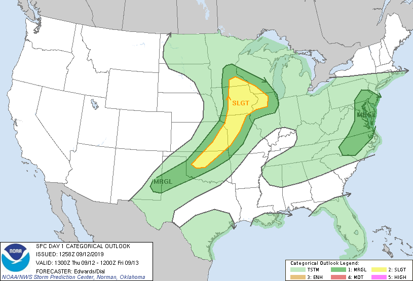
Portions of Minnesota and Wisconsin could also see some severe weather Thursday afternoon and evening.
The National Weather Service Storm Prediction Center shows a slight risk of severe weather Thursday and Thursday night for parts of south-central and southeastern Minnesota plus southwestern Wisc., with a marginal risk of severe weather extending through portions of southern and central Minnesota, including the Twin Cities metro area, and west-central Wisconsin:

Slight risk means that scattered severe thunderstorms are possible, while marginal risk means that an isolated severe thunderstorm is possible. The Storm Prediction Center will update the severe weather outlook late Thursday morning and also Thursday afternoon and evening.
Temperature trends
Thursday highs will range from the 50s in far northern Minnesota to the 70s in the far south. The metro area peak in the 60s.
Friday highs will be in the 50s north with 60s to the south:

Saturday highs rebound to the 60s north and 70s south:

Sunday highs range from the lower 80s and the 70s in the south to the 60s north:

Twin Cities metro area highs are projected to reach the lower 80s Monday through Wednesday of next week.
Wednesday tornado in Winona
The NWS confirmed that an EF-1 tornado touched down in Winona, Minn., Wednesday morning:
Here’s some Winona tornado damage video from Wednesday:
Thankfully, there weren’t any reports of injuries from the Winona tornado.
Programming note
You can hear my live weather updates on Minnesota Public Radio at 7:49 a.m. Thursdays and Fridays, and at 7:35 a.m., 9:35 a.m. and 4:35 p.m. each Saturday and Sunday.


