A quick blast of snow Wednesday, followed by a crippling snowstorm Friday
Two more rounds of Arctic cold are on the way
Go Deeper.
Create an account or log in to save stories.
Like this?
Thanks for liking this story! We have added it to a list of your favorite stories.
Another bout of mostly light snow is making its way across Minnesota Wednesday, followed by dangerous cold and a major snowstorm.
Wednesday’s forecast
Predominantly light snow is making its way across Minnesota Wednesday. Here is the radar as of 8:38 a.m.:

There is a corridor of slightly heavier snow across northern Minnesota from Moorhead to Duluth that could see totals of 2-4 inches, while the rest of the state will mostly see zero to 2 inches Wednesday.

For the Twin Cities, the snow totals will likely be in the 1- to 2-inch range, and it will already be winding down by midday.
Turn Up Your Support
MPR News helps you turn down the noise and build shared understanding. Turn up your support for this public resource and keep trusted journalism accessible to all.
For southern Minnesota, freezing rain could mix in with the snow through Wednesday morning, causing slick roads. In the Arrowhead, snow could linger through the evening. Most of the snow will move out of Minnesota by Wednesday afternoon.
Cold air is continuing to funnel across the state, and portions of western Minnesota are seeing falling temperatures through Wednesday. By the afternoon, temperatures will range from negatives in northwestern Minnesota to 20s southeast.

Another round of dangerous cold
As temperatures continue to drop, Thursday morning will be dangerously cold, with the entire state likely to start the day below zero. Adding in the wind, wind chills for most of the state will dip to minus 20 to minus 35 degrees at times overnight Wednesday and through Thursday morning.

Daytime temperatures also remain cold, with northern Minnesota below zero, and southern Minnesota only seeing single-digit highs.
Despite the cold, Thursday will likely be the sunniest day of the week, with sunshine through the afternoon. By late afternoon clouds increase again ahead of our next storm.
A crippling snowstorm hits Friday
A major winter storm starts spreading snow across southern Minnesota overnight Thursday, and the entire state will likely see snow by Friday morning.
Southern Minnesota could also see light freezing rain mix in late Friday. Snow will continue all of Friday and through Saturday morning, before slowly clearing out Saturday afternoon.
Right now, it looks as though the center of the storm may track just south of Minnesota, bringing the heaviest snow to southern Minnesota, where almost everyone could see at least 6 inches.

Totals could be slightly less for northern Minnesota, being farther from the storm center.
It also looks like a heavier corridor of snow could set up in south central Minnesota, including the Twin Cities, where widespread areas of 8 inches or more are likely. Some models bring that heavier snow band potential closer to a foot of snow.
Here is the Nested Grid Model showing those possibly higher totals:

So, while there is some uncertainty of the exact area that will see the heaviest snow, and how high the totals will go, this will be a major snow event with severe travel impacts Friday and Saturday.
Another concern with this storm is high winds both Friday and Saturday, with gusts that will exceed 30 mph for almost the entire state.

Especially on Saturday, that could cause reduced visibility with areas of blowing snow.
Temperatures plummet again
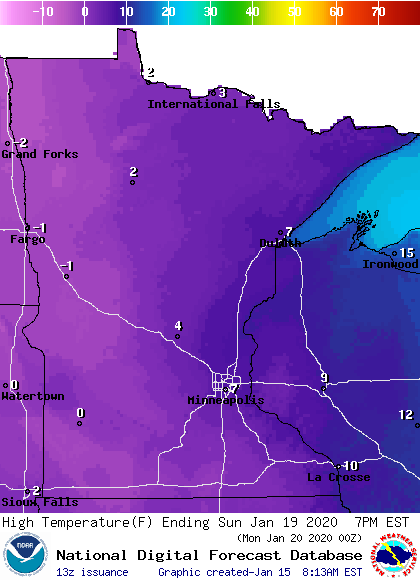
The winter storm that moves in Friday briefly warms temperatures back into the 20s on Friday, then sends temperatures crashing Saturday, leaving the entire state back below zero by Sunday morning.
Very cold air stays over Minnesota the first few days of next week, with highs only in the single digits and a few places that never make it above zero.

Programming note
You can hear my live weather updates on Minnesota Public Radio at 7:48 a.m. Monday through Friday morning.


