Windy with a morning rain/snow mix, then a rain shower chance this afternoon
Advisories in some areas this morning
Go Deeper.
Create an account or log in to save stories.
Like this?
Thanks for liking this story! We have added it to a list of your favorite stories.
The low pressure system that brought rain to some areas overnight and a rain/snow mix or snow to other areas is slowly moving away. It’ll continue to spin moisture and precipitation over eastern Minnesota and western Wisconsin Sunday morning, with precipitation tapering off from west to east this afternoon.
The National Oceanic and Atmospheric Administration’s North American Mesoscale forecast model shows the potential precipitation pattern Sunday morning through Sunday evening:

The Twin Cities metro area will see a rain/snow mix this Sunday morning, with a few rain showers possible in the afternoon.
Advisories and warnings
Turn Up Your Support
MPR News helps you turn down the noise and build shared understanding. Turn up your support for this public resource and keep trusted journalism accessible to all.
The winter weather advisory for portions of central Minnesota was discontinued at 6:48 a.m. this Sunday.
Parts of Northeastern Minnesota and northwestern Wisconsin have a winter storm warning until 11 a.m. :

Details of the winter storm warning:
URGENT - WINTER WEATHER MESSAGE National Weather Service Duluth MN 419 AM CDT Sun Mar 29 2020 ...HEAVY WET SNOW EXPECTED OVERNIGHT THROUGH SUNDAY MORNING... .A strong spring storm system will bring a rain and snow mix to the Northland tonight through Sunday. Rain was occurring over northern Wisconsin. As low level temperatures cool the rain is expected to mix with and change to snow tonight over much of northern Wisconsin and central into northeast Minnesota. The precipitation will then switch back to mainly rain through the day Sunday. The precipitation will be associated with strong northeast winds tonight with gusts to 40 to 45 mph, especially near Lake Superior. Snowfall amounts of 3 to 9 inches are possible, along with some locally higher amounts along the South Shore of Lake Superior over Douglas and Bayfield counties, and along the North Shore of Lake Superior. Uncertainty in snowfall amounts remains based on how fast rain may change to snow and the area of heaviest precipitation. We have upgraded the Winter Weather Advisory for the Twin ports area northeast through the Arrowhead to a Winter Storm Warning for higher snowfall amounts. MNZ012-019>021-037-291600- /O.CON.KDLH.WS.W.0003.000000T0000Z-200329T1600Z/ Northern Cook and Lake-Central St. Louis-Southern Lake- Southern Cook-Carlton and South St. Louis- Including the cities of Isabella, Hibbing, Two Harbors, Silver Bay, Grand Marais, and Duluth 419 AM CDT Sun Mar 29 2020 ...WINTER STORM WARNING REMAINS IN EFFECT UNTIL 11 AM CDT THIS MORNING... * WHAT...Heavy snow. Additional snow accumulations of up to 4 inches. Winds gusting as high as 35 mph, with gusts approaching 50 mph near Lake Superior. * WHERE...Central St. Louis, Northern Cook and Lake, Carlton and South St. Louis, Southern Cook and Southern Lake Counties. This includes the Tribal Lands of the Bois Forte Band, Lake Vermillion area, the Grand Portage Reservation and the Fond du Lac Band. * WHEN...Until 11 AM CDT this morning. * IMPACTS...Plan on slippery road conditions. Patchy blowing snow could significantly reduce visibility. PRECAUTIONARY/PREPAREDNESS ACTIONS... If you must travel, keep an extra flashlight, food, and water in your vehicle in case of an emergency. The latest road conditions can be obtained by calling 5 1 1. Road conditions can also be found at 511mn.org for Minnesota or 511wi.gov for Wisconsin.
The winter weather advisory for Pine county also continues to 11 a.m. this Sunday.
You can hear updated weather information on the MPR network, and you’ll see updated weather info on the MPR News live weather blog.
Snow reports can be found here. You can hover over any snow report to get the exact snow total, plus the location and time of measurement. You can also slide the map to show snow in other parts of Minnesota and Wisconsin.
Temperatures and winds
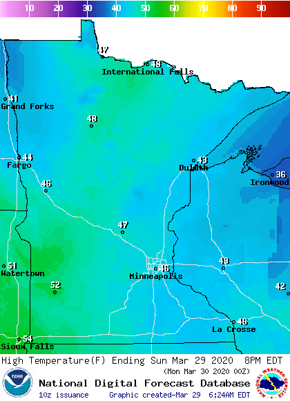
Sunday highs will be mainly in the 40s, with a few lower 50s possible in the southwest:

It won’t feel as warm as the temps, due to gusty winds. Here are some peak wind gusts for today:

An updated updraft blog will be posted by around 10 a.m. today.
Programming note
You can hear my live weather updates on MPR News at 7:35 a.m., 9:35 a.m. and 4:35 p.m. each Saturday and Sunday.


