Much better weather on Monday; rain returns midweek
Recap of the weekend soaker, plus a look at river levels
Go Deeper.
Create an account or log in to save stories.
Like this?
Thanks for liking this story! We have added it to a list of your favorite stories.
We saw plenty of rain Saturday afternoon and Saturday evening. Parts of Minnesota and western Wisconsin had wet snow or a mix of rain and snow Saturday night, which transitioned to mainly rain on Sunday.
Here are the precipitation totals (rain plus the water content of snow) for the 24-hour period ending at 7 a.m. Sunday:

The yellow-shaded area shows 1.5 to 2 inch totals.
St. Cloud set a precipitation record for March 28:
Turn Up Your Support
MPR News helps you turn down the noise and build shared understanding. Turn up your support for this public resource and keep trusted journalism accessible to all.
The weekend precipitation total at MSP airport was 1.29 inches.
Weekend snow totals were highest from central Minnesota into northeastern Minnesota and the far northwestern corner of Wisconsin:

Snow reports can be found here. You can hover over any snow report to get the exact snow total, plus the location and time of the measurement. You can also slide the map around to show snowfall reports from other parts of Minnesota and Wisconsin. If you go to the linked site on Monday, move the slider in the upper left corner to “48 hours” to get all the weekend reports.
A dry Monday, then rain returns midweek
Most of Minnesota and western Wisconsin will enjoy dry weather on Monday. The next meaningful precipitation arrives late Tuesday night or Wednesday. The National Oceanic and Atmospheric Administration’s North American Mesoscale forecast model shows the potential precipitation pattern for Wednesday and Wednesday evening:

Parts of far northern Minnesota could see a combo of rain and snow on Wednesday.
You can hear updated weather information on the MPR network, and you’ll see updated weather info on the MPR News live weather blog.
Temps rebound
Monday highs reach the 50s across most of Minnesota and western Wisconsin:

Portions of northern Minnesota will top out in the 40s. I expect highs in the upper 50s in parts of the Twin Cities metro area. Our average March 30 high in the Twin Cities is 49 degrees.
Twin Cities metro area highs are projected to reach the mid 50s on Tuesday, followed by lower 50s Wednesday and Thursday and around 50 on Friday.
River levels are rising
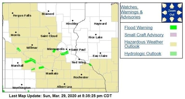
The soaking weekend rains will contribute to rising river levels across southern Minnesota in the coming days. Flood warnings have been issued along some rivers in southern Minnesota, and the warnings are shaded green on this map:

You can click on any green-shaded location at the NWS site to get flood warning details. Here’s a Sunday update from the NWS:
Flood Warning National Weather Service Twin Cities/Chanhassen MN 923 AM CDT Sun Mar 29 2020 ...The National Weather Service in Chanhassen has issued a flood warning for the following rivers in Minnesota... Minnesota River at Savage affecting Dakota...Hennepin and Scott Counties South Fork Crow River below Mayer affecting Carver County Redwood River near Redwood Falls affecting Redwood County .One to two inches of rainfall has fallen the past 24 hours over much of south and central Minnesota. This has led to increases in most rivers. Current forecasts project only minor flooding, but additional precipitation events over the next 7 days could cause further rises. The National Weather Service will monitor this developing situation and issue followup statements as conditions or forecasts change. PRECAUTIONARY/PREPAREDNESS ACTIONS... Do not drive cars through flooded areas. Turn Around...Don`t Drown. Stay tuned to NOAA Weather Radio or your local radio or TV station for the latest information concerning this flood event. && MNC037-053-139-302023- /O.NEW.KMPX.FL.W.0015.200331T1200Z-000000T0000Z/ /SAVM5.1.ER.200331T1200Z.200405T0000Z.000000T0000Z.NO/ 923 AM CDT Sun Mar 29 2020 The National Weather Service in Chanhassen has issued a * Flood Warning for The Minnesota River at Savage. * from Tuesday morning until further notice. * At 9:00 AM Sunday the stage was 700.2 feet. * Minor flooding is forecast. * Flood stage is 702.0 feet. * Forecast...Rise above flood stage by Tuesday morning and continue to rise to near 706.5 feet by Saturday evening. additional rises are possible thereafter. * Impact...At 705.0 feet...Flood waters begin to impact the park road at Fort Snelling State Park.
Red River update
River level forecasts are updated on a regular basis. You can click on any location on the NWS Advanced Hydrologic Prediction Service (AHPS) site to get hydrographs of recent and forecast river levels. Some locations list levels in feet above sea level, others list levels in feet above a local reference point.
Here’s the Sunday evening hydrograph for the Red River at Fargo, North Dakota:

The hydrograph shows the Red River reaching major flood stage at Fargo on Wednesday. The 30- foot level forecast on Wednesday is well below the 40.82 ft. record flood level reached on March 28, 2009 (instantaneous measurement), according to the AHPS site.
It’s a good thing that the soaking rains this weekend missed northwestern Minnesota and eastern North Dakota!


