Periods of severe weather possible through Thursday
And excessive heat warning for the Twin Cities Wednesday
Go Deeper.
Create an account or log in to save stories.
Like this?
Thanks for liking this story! We have added it to a list of your favorite stories.
A potent storm is bringing everything from severe weather to extreme heat across Minnesota. Behind the system, temperatures return closer to average for the weekend.
Storm impacts through Thursday
A strong summer storm is moving showers and storms across Minnesota. Early Wednesday, they even caused some areas of severe weather, including 83 mph winds reported at the Fergus Falls airport.
Here is where they are as of 8:38 a.m. Wednesday:

The storms will both diminish and move out of the state through the morning and be much spottier in the afternoon. Then, fueled in part by heat and humidity, storms are likely to redevelop Wednesday afternoon and evening.
Turn Up Your Support
MPR News helps you turn down the noise and build shared understanding. Turn up your support for this public resource and keep trusted journalism accessible to all.

Much of central through northeastern Minnesota is under a risk for severe weather Wednesday, then the risk shifts to the southeastern corner of the state on Thursday.

With any severe weather, hail and damaging wind are the primary threat, but isolated tornadoes are possible as well. Periods of heavy rain are also likely with strong storms.
It currently looks like the heaviest rain with the system could target northern and central Minnesota, with some widespread totals over and inch of rain possible.
For the Twin Cities, the timing for storms is likeliest to be late Wednesday evening and overnight, with some lingering showers and storms into Thursday.
Eastern and southern Minnesota are likely to see additional showers and storms Thursday before everything finally clears out Thursday evening.
This storm is also bringing southerly winds Wednesday that will gust to over 20 mph by afternoon. This funnels in hot and very humid air across the state.
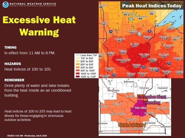
Temperatures Wednesday afternoon will be in the 80s for northern Minnesota and 90s south. High dew points in the 70s will make the day very muggy and push the heat index over 100 degrees for parts of the state, including the Twin Cities.
Because of this, much of southern Minnesota is under a heat advisory, and the Twin Cities metro area is under an excessive heat warning from 11 a.m. to 8 p.m. Wednesday.

Winds shift Thursday as the cold front associated with the storm moves across Minnesota. This brings all of Minnesota back into the 80s Thursday, and brings in slightly lower humidity.
Extended forecast
Behind the storm system Wednesday and Thursday, Friday stays relatively quiet. Temperatures Friday start in the 50s and 60s, then reach into the 80s for highs under plenty of sunshine.
Another disturbance moves across Minnesota over the weekend, bringing back the chance for scattered showers and storms, especially on Saturday. Temperatures won’t be as hot as some of our recent weather, but highs stay at or above average and in the 80s.
Here is the forecast for the Twin Cities through Sunday:

Programming note
You can hear my live weather updates on Minnesota Public Radio at 7:48 a.m. Monday through Friday morning.


