

Showers, thunderstorms and turning much cooler
Go Deeper.
Create an account or log in to save stories.
Like this?
Thanks for liking this story! We have added it to a list of your favorite stories.
Round 1 of thunderstorms crossed Minnesota into Wisconsin Monday night. Round 2 is already revving up early Tuesday morning.
An umbrella Tuesday
A trailing cold front and strong mid-level forcing are working together to spread areas of showers and thunderstorms toward Minnesota from the southwest.
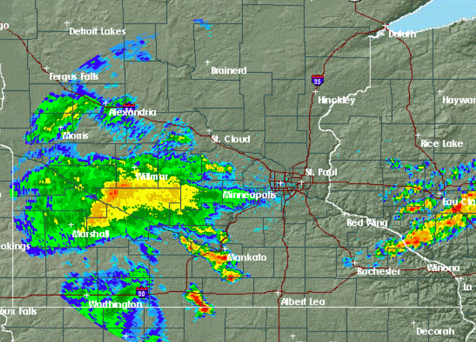
For the Twin Cities, that first large cluster of showers and storms will arrive across the entire metro area during the morning commute. Then look for periods of rain and occasional thunder through most of the day.
Much of Minnesota except the northwest will get wet today. The greatest rainfall totals are likely across about the southern third of Minnesota and into Wisconsin where many locations could pick up one to two inches of rain. Locally-greater amounts are possible in southeastern Minnesota. Some flash flooding is possible, mainly south and east of the Twin Cities.
Turn Up Your Support
MPR News helps you turn down the noise and build shared understanding. Turn up your support for this public resource and keep trusted journalism accessible to all.
Severe possibilities
While excessive rainfall is the main risk from this weather system, there is a chance of severe weather Tuesday afternoon or evening, mainly from southeastern Minnesota well into Wisconsin.

Temperatures will slide downward as the rain moves across the area. The Twin Cities began Tuesday with temperatures in the upper 70s. Expect readings to drop into the cool-for-July 60s during the day.
Beautiful Wednesday
Sunshine, seasonal temperatures and much lower dew points in the 50s are on tap for Wednesday.
Thursday looks like a great day, also, with just a few isolated thunderstorms possible.
Heat, humidity and storms by late in the week
Heat and humidity will return in abundance on Friday and hang around through the weekend.

Strong or even severe thunderstorms are possible, mainly responding to the heating of the day on Friday and Saturday.