

Colder temperatures lie ahead this week
Sunday turns breezy and parts of the state receive spotty showers
Go Deeper.
Create an account or log in to save stories.
Like this?
Thanks for liking this story! We have added it to a list of your favorite stories.
Minnesota will see seasonable weather Sunday, but temperatures slide even colder by the end of the week. Light rain chances linger most of the week.
Sunday’s forecast
Thanks to a couple cold fronts that have passed through the state recently, the warmer weather of last week has been replaced with much more seasonable weather.
Sunday started in the 40s and 50s, and highs will make it into the 50s and 60s, with most places very close to average for late September.

Another weak cold front is pushing into northern Minnesota as of Sunday morning, bringing showers to that portion of the state. By late afternoon, that precipitation chance spreads into southern Minnesota.

Any rainfall should stay light, with most places under a quarter inch of rain, and while an isolated storm is possible, no severe weather is expected.
Turn Up Your Support
MPR News helps you turn down the noise and build shared understanding. Turn up your support for this public resource and keep trusted journalism accessible to all.
The front is also bringing breezier conditions, with wind gusts into the 20 to 30 mph range by afternoon, especially in western Minnesota.
A cooler week
A series of cold fronts will keep temperatures cool and spotty rain chances around for the entire week. Even though the active weather keeps at least some chance for showers in the forecast most days, precipitation should remain light, with most of the state expecting less than a half inch of rain total through Saturday.

The state has been in a big rain deficit for September, so this means most of Minnesota will end September much drier than average.
The cold fronts also will reinforce cooler air across the state, plunging temperatures from near average Sunday to below average for the rest of the week. Most of Minnesota drops down to highs in the 50s Monday and we stay in the 50s and 60s through mid-week.
Here is that forecast trend for the Twin Cities:
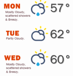
Then the second half of the week turns even colder, with highs only in the 40s and 50s. This also brings the potential for lows in the 30s the second half of the week, so we will have to monitor for frost and freeze concerns.

Programming note
You can hear my live weather updates on Minnesota Public Radio at 7:48 a.m. Monday through Friday morning.