Bright and colder on Sunday; searching for warmth
Some Saturday snow reports from northern Minnesota
Go Deeper.
Create an account or log in to save stories.
Like this?
Thanks for liking this story! We have added it to a list of your favorite stories.
October snow gets our attention:


It snowed across much of northern Minnesota this Saturday, with several inches in some locations. Some preliminary Saturday snow reports have come in from northern Minnesota, including four inches at Park Rapids and Grand Rapids and just under 2 inches at the Duluth airport. Many observers will take snow measurement at 6 p.m. or 7 p.m., so additional snow totals will arrive as we go through Saturday evening.
You can see snow totals as they are posted by the National Weather Service here. The NWS snow plot looked like this at 5:30 p.m. Saturday:

Snow continued into Saturday evening in northeastern Minnesota, where a winter weather advisory will expire at 10 p.m. this Saturday.
Turn Up Your Support
MPR News helps you turn down the noise and build shared understanding. Turn up your support for this public resource and keep trusted journalism accessible to all.
Far southern Minnesota can expect some Saturday evening rain showers. A few showers are also possible Saturday evening in the southern part of the Twin Cities metro area.
You can hear updated weather information on the MPR network, and you’ll see updated weather info on the MPR News live weather blog.
Cold Sunday
Our Saturday high of 53 degrees at Minneapolis-St. Paul International Airport was 5 degrees shy of our average Oct. 17 high. Sunday will be downight cold, as we top out in the lower 40s.
Southern Minnesota will see Sunday highs in the lower 40s, with mainly 30s elsewhere:

Sunday afternoon winds could gust from 15 to 20 mph:

Plotted values are in knots, with 14 knots equal to around 16 mph. Gusts over 22 mph are possible Sunday afternoon in northwestern Minnesota.
Temperature trends
Twin Cities metro area highs are projected to reach the lower 40s Monday, then around 40 Tuesday, mid 40s Wednesday and upper 40s on Thursday before dropping back to lower 40s on Friday.
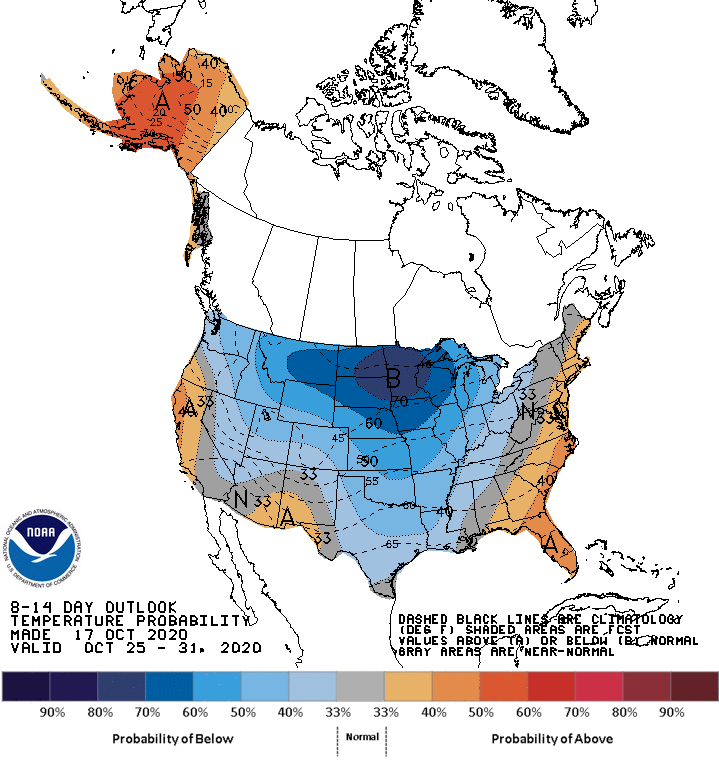
No big warmup is in sight. It looks like chilly temps will linger into next weekend and through the following week. The NWS Climate Prediction Center temperature outlook for Oct. 25 through Oct. 31 shows a strong tendency for below-normal temperatures in Minnesota and Wisconsin:

I wish that I had milder temps to talk about!
Programming note
You can hear my live weather updates on MPR News at 7:35 a.m., 9:35 a.m. and 4:39 p.m. each Saturday and Sunday.


