Smoke and haze return across Minnesota Tuesday
An area of isolated showers and storms dips farther south
Go Deeper.
Create an account or log in to save stories.
Like this?
Thanks for liking this story! We have added it to a list of your favorite stories.
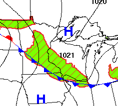
A cold front moving across the state continues to bring chances for showers and storms. Meanwhile, the wind shift behind the front has funneled more smoke back into northern Minnesota.
Tuesday’s forecast
A cold front that began its slow trek into northern Minnesota Monday has now cleared through central Minnesota as of Tuesday morning and will continue to dip southeast through the day.
Despite some cooler air with that boundary, the state is off to a warm start, with most morning temperatures in the 60s.
However, afternoon temperatures will be slightly cooler behind the front, with 70s and 80s north, while southern Minnesota still sees 90s.
Turn Up Your Support
MPR News helps you turn down the noise and build shared understanding. Turn up your support for this public resource and keep trusted journalism accessible to all.

Unfortunately, a northerly flow behind the front is drawing smoke back in from the Canadian fires, so most of the state will see more haze again Tuesday. For northern Minnesota, more of the smoke is also at the surface, putting much of the area under an air quality alert once more.
Stagnant conditions also have much of northern Minnesota seeing morning fog.

The frontal boundary continues to serve as a trigger for isolated showers and storms, which are most likely from northwestern to southeastern Minnesota. This includes a chance for isolated activity around the Twin Cities Tuesday afternoon and evening.
Overall, rainfall will be limited, but there are occasional amounts over a half inch with persistent thunderstorms.
The week ahead rains hot with only spotty rain chances.
That extended forecast will be updated around 9 a.m.
Programming note
You can hear my live weather updates on Minnesota Public Radio at 7:48 a.m. Monday through Friday morning.


