Recap of overnight rain totals, plus a look at hot weekend temps
Drier air spreads southward Saturday afternoon
Go Deeper.
Create an account or log in to save stories.
Like this?
Thanks for liking this story! We have added it to a list of your favorite stories.
Cleanup from Friday’s severe thunderstorms continues this Saturday in Ely, Minnesota:
The radar image is from Friday.
The Blueberry/Art Festival in Ely has been cancelled for this weekend:
Thunderstorm damage was reported in several locations overnight, including Chisago City in Chisago County, where numerous power lines were downed and some 18-24 inch diameter trees were toppled.
Turn Up Your Support
MPR News helps you turn down the noise and build shared understanding. Turn up your support for this public resource and keep trusted journalism accessible to all.
Welcome rain
Thursday’s U.S. Drought Monitor report showed 72 percent of Minnesota in either extreme drought (shaded red) or severe drought (shaded orange):

If you include the moderate drought areas (shaded beige), then 98.19 percent of Minnesota was in drought on the Thursday map, which had a rainfall cutoff of 7 a.m. on Tuesday.
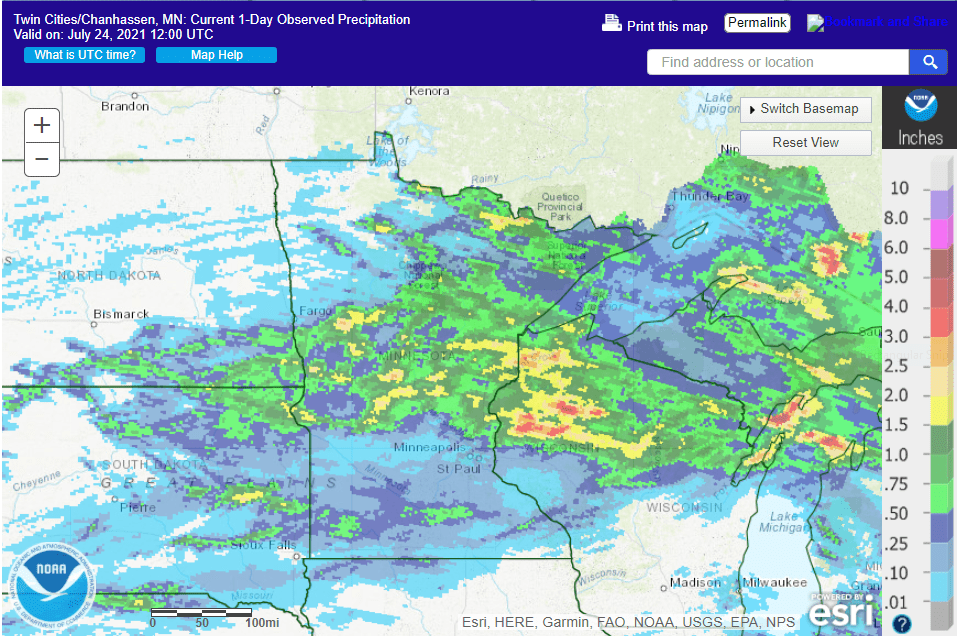
Rainfall from Friday through the overnight hours of Friday night was heaviest in parts of northern and central Minnesota and northwestern Wisconsin:

Some 1 to 2 inch rainfall totals were reported since Friday afternoon in parts of central and northern Minnesota and into northwestern Wisconsin. Radar estimates show higher totals of 2 to 4 inches from south of Aitkin to Moose Lake and Barnum, Minn., and over to Hayward, Wis. There was an interesting contrast across Stearns County in central Minnesota; 2.15 inches in Sauk Centre of northwestern Stearns County, but just 15/100ths of an inch in St. Cloud in eastern Stearns County.
Most of the Twin Cities metro area saw less than 1/10th of an inch of rain overnight, with just .02” at MSP Airport. The northern edge of the metro had some decent totals; one-half inch to one inch of rain fell overnight in northern Anoka County and in far northern Washington County.
Here’s a closer look at amounts:
Radar estimates show that 2-4 inches of rain fell in a swath from Amery, Wis., to Turtle Lake, Wis.
No significant rain is expected in Minnesota or western Wisconsin Saturday afternoon through Sunday afternoon. Southwestern Minnesota could see a Sunday evening shower or thunderstorm.
Hot weather continues
Saturday highs will reach the 90s across roughly the southern half of Minnesota and most of western Wisconsin. Northern Minnesota will see a lot of 80s. Dew points will be sticky in southern Minnesota and the Twin Cities metro area until drier dew points ride in on northwesterly breezes around mid afternoon.
Sunday highs will also reach the 90s south, with 80s to the north:

Sunday dew points will be fairly comfortable, in the 50s:

Back to forecast highs, Twin Cities metro area high temps are projected to reach the mid 90s Monday, followed by upper 90s Tuesday and Wednesday. Highs retreat to the upper 80s for Thursday and Friday. Our best chance of showers and thunderstorms will be on Wednesday.
Weather nugget
Our official Twin Cities high temp has reached 90 degrees or warmer on 17 days this year. We average 13 days of 90 or warmer per year in the Twin Cities.
Programming note
You can hear my live weather updates on MPR News at 7:35 a.m., 9:35 a.m. and 4:39 p.m. each Saturday and Sunday.


