

Greenwood Fire weather forecast: Southerly winds, dry weather until Friday night
Winds will push fires northward this week
Go Deeper.
Create an account or log in to save stories.
Like this?
Thanks for liking this story! We have added it to a list of your favorite stories.
We’re watching fire weather conditions for the fire zone in northeast Minnesota this week.
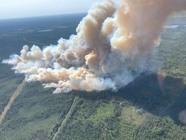
The Greenwood Fire is now growing from 2,000 acres. Here’s Tuesday’s update from the US Forest Service Facebook page:

Three other smaller wildfires are also burning in northeast Minnesota.
Fire weather forecast
The overall meteorological pattern favors persistent southerly wind flow through Friday. South winds between 10 and 20 mph will be common in northeast Minnesota this week. Locally higher gusts can occur in fire zones as wildfires can actually change the local atmosphere and modify local weather conditions.
Support Local News
When breaking news happens, MPR News provides the context you need. Help us meet the significant demands of these newsgathering efforts.
One weather factor helping firefighters will be relatively high dew points this week. Dew points in the 60s in the fire zone will keep humidity levels relatively high.
NOAA’s NAM model output favors dew points in the 60s and southerly winds into Friday. Here’s the loop between 7 p.m. Tuesday and 1 p.m. Wednesday.

High temperatures will reach the upper 80s and low 90s in the fire zone this week.

Overnight low temperatures will favor the lower 60s this week.

Rain chance late this week
Little if any rain is forecast in the fire zones in northeast Minnesota through Thursday. A cold front approaching Friday will bring a chance of scattered rain and thunderstorms Friday night into Saturday.

A second system may bring another chance for rain by Monday. The European model favors multi-inch rainfall for parts of Minnesota by Monday night. But Tuesday’s moels runs favor less than an inch in the fire zones. That could change, but here’s the latest European model run.

Weather conditions favor continued fire growth this week. But if the humidity stays high and winds stay manageable, fire crews may be able to make some containment progress.
Stay tuned.