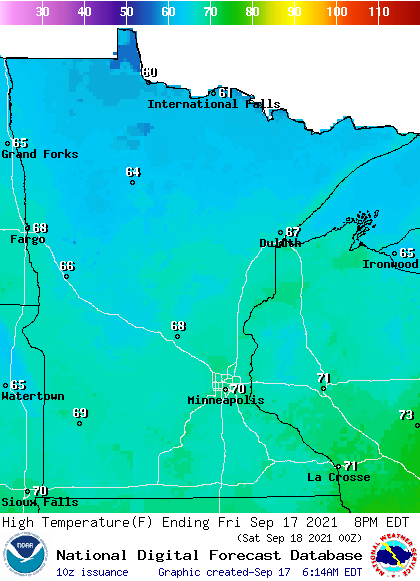
Behind the storms overnight, cooler weather on Friday
Southern Minnesota already saw its highs for the day
Go Deeper.
Create an account or log in to save stories.
Like this?
Thanks for liking this story! We have added it to a list of your favorite stories.
In the wake of the cold front that moved through Minnesota overnight, sunshine returns but temperatures turn cooler.
Friday’s forecast
Active weather targeted Minnesota form Thursday evening through the overnight as a long line of severe storms cut across Minnesota associated with a cold front.
As of 7 a.m., the front has cleared through all but the southeastern corner of the state, where there are a few lingering showers that continue to move out through the morning.

Ahead of the front there is very warm air, so southeastern Minnesota is still in the 60s Friday morning. A much cooler air mass is behind the front, putting the rest of the state in the 40s and 50s for lows Friday morning.
Turn Up Your Support
MPR News helps you turn down the noise and build shared understanding. Turn up your support for this public resource and keep trusted journalism accessible to all.
Afternoon temperatures will be noticeably cooler than Thursday, with most of Minnesota stuck in the 60s, and a few temperatures near 70s south.

For much of southern Minnesota, the Friday afternoon temperatures will not be the highs for Friday. Those occurred just after midnight when temperatures were still in the mid- and upper 70s coming off the 80s that part of the state saw on Thursday.
Skies do clear quickly as the cold front exits, so while it will be cooler Friday, there will also be plenty of sunshine.
The cooler air could lead to a few spots of frost by Saturday morning, but overall the weekend looks pleasant.
That extended forecast will be updated by 9:30 a.m.
Programming note
You can hear my live weather updates on Minnesota Public Radio at 7:48 a.m. Monday through Friday morning.


