Temps retreat on Tuesday; Wednesday looks soggy
Fall color update for leaf-peepers
Go Deeper.
Create an account or log in to save stories.
Like this?
Thanks for liking this story! We have added it to a list of your favorite stories.
Our mild October weather continued on Monday. The Monday high temp at Minneapolis-St. Paul International Airport was 71 degrees. That was 10 degrees warmer than our average Oct. 11 high in the Twin Cities.
Our official Twin Cities high temp has been in the 70s every day this month. That streak is expected to end on Tuesday.
Temperature trends
Most of Minnesota and western Wisconsin will see Tuesday highs in the 60s:

Far northwestern Minnesota will see a few 50s.
Turn Up Your Support
MPR News helps you turn down the noise and build shared understanding. Turn up your support for this public resource and keep trusted journalism accessible to all.
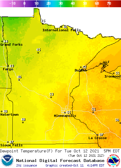
Tuesday dew points will be in the comfortable 40s and 50s:

Back to high temps, Twin Cities metro area highs are projected to reach the mid 60s Wednesday. Cooler temps move in to end the week, with highs around 60 on Thursday and in the mid 50s on Friday. Highs then rebound to around 60 next weekend. It looks like above-normal temps could return the following week.
The NWS Climate Prediction Center shows a tendency for above normal temperatures in Minnesota and Wisconsin from Oct. 17 through Oct. 21:

Wednesday rain!
Much of Minnesota is still experiencing drought, so we’re looking for rain opportunities.
A strong low pressure system will spin moisture over the upper Midwest from late Tuesday night through Wednesday. We’ll have periods of rain across Minnesota and Wisconsin on Wednesday, with some embedded thunderstorms at times.
National Oceanic and Atmospheric Administration’s North American Mesoscale (NAM) forecast model shows the potential rain pattern Wednesday and Wednesday evening:

Parts of western Minnesota could see more than one inch of rain on Wednesday, with less than one inch in eastern Minnesota and western Wisconsin.
You can hear updated weather information for Minnesota and western Wisconsin on the Minnesota Public Radio News network, and you can see updated weather info on the MPR News live weather blog.
Oct. 9 tornado in Park Rapids
The National Weather Service has released their damage survey regarding the tornado that touched down in Park Rapids, Minn. Saturday evening:

Thankfully, the tornado didn’t cause any injuries or fatalities. Photos of storm damage and the radar loop from Saturday evening can be found in the full NWS report.
Fall color report
The percentage of changeover to fall colors is highest in the northern half of Minnesota plus west-central Minnesota and the northeastern part of the Twin Cities metro area. Here’s the latest fall color report from the Minnesota Department of Natural Resources:

The dark-red shaded areas are past peak. Keep in mind that all deciduous trees are included in the fall color report, not just maples.
Wisconsin fall color info can be found here.
Programming note
You can hear my live weather updates on MPR News at 7:35 a.m., 9:35 a.m. and 4:39 p.m. each Saturday and Sunday.


