Temperatures tumble from 70s Monday to 40s late-week
A midweek storm brings Minnesota rain and possibly snow
Go Deeper.
Create an account or log in to save stories.
Like this?
Thanks for liking this story! We have added it to a list of your favorite stories.
Minnesota goes from almost 20 degrees above average to much more seasonable but chilly highs in the 40s and 50s thanks to a storm that hits Wednesday.
Monday’s forecast
Following a warm Sunday where Minnesota saw highs well above average, Monday started mild for late October despite clear skies overnight. Most of the state began the day in the 40s, with a few 30s north, and a couple upper 20s in the Arrowhead.
Combined with warm southerly winds, most of Minnesota has highs forecast in the 70s Monday along with widespread sunshine.

This is 15 to 20 degrees above average for most places.
Turn Up Your Support
MPR News helps you turn down the noise and build shared understanding. Turn up your support for this public resource and keep trusted journalism accessible to all.
The southerly winds that help warm us on Monday will be breezier in the afternoon, and western Minnesota in particular can expect gusts over 20 mph.
A storm brings changes
Tuesday will be very similar to Monday with plentiful sunshine and most of the state well above average.
However, northwestern Minnesota will already start to see some of the cooler air filter in ahead of a storm that moves across Minnesota Wednesday. Because of this, there will be a temperature contrast across Minnesota, with highs ranging from the 50s northwest to highs still in the 70s south.

By Tuesday night, that storm starts moving rain into southern Minnesota, and the precipitation spread quickly overnight, with most of the state seeing a chance for shower by the Wednesday morning commute.
Although most of the precipitation will be rain, temperatures will be cold enough in northern Minnesota for a couple flakes of snow to mix in northwest early Wednesday.
Because the low pressure of the storm is expected to track across southern Minnesota, precipitation in the northwestern corner of the state will be sparse, so snow accumulation is not currently expected.
The rest of the state is projected to see about one-quarter to one-half inch of rain.

There could be a couple of isolated thunderstorms in southwestern Minnesota, which could mean a few localized higher rainfall amounts.
The rain moves out quickly, clearing out of most of Minnesota by late Wednesday evening.
That storm continues to pull in much colder air behind it.

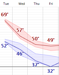
Most of the state will be in the 40s north and 50s south Wednesday as the system passes through. By Thursday and Friday, almost all of Minnesota will see highs only in the 40s, with a couple isolated low 50s south.
Here is that forecast for the Twin Cities showing the dramatic plunge:
Although this will feel cold compared to the warmth the first part of this week, highs in the 40s and 50s are actually much more seasonable.
By Saturday, Oct. 23, the normal high in the Twin Cities is 53 degrees and for International Falls it is 47.
For the few places in Minnesota, mostly around the Twin Cities, that have yet to see frost, morning lows Friday and Saturday morning will bring widespread frost to the state and finally end the growing season for the few remaining places yet to get frost.
Those chillier, more seasonable temperatures linger through the weekend, but already by next week the state is expected to return to above average temperatures.

This is likely to include the return of highs in the 60s, especially in southern Minnesota. We will keep you updated as we get closer to next week!
Programming note
You can hear my live weather updates on Minnesota Public Radio at 7:48 a.m. Monday through Friday morning.


