Christmas eve warm front; snow chance emerging Sunday and Monday
Good travel weather through Christmas day. Significant snow system possible Sunday and Monday.

Go Deeper.
Create an account or log in to save stories.
Like this?
Thanks for liking this story! We have added it to a list of your favorite stories.
Here comes another out-of-season warm front for Minnesota.
Minnesota is riding the tip of another unseasonably warm late December air mass. A warm pool of temperatures in the 60s and 70s covers the southern plains as close as Kansas Thursday. Highs in the 80s are common in Texas.

We hit 39 degrees in the Twin Cities Thursday afternoon. That’s 13 degrees warmer than our average of 26 degrees for December 23.
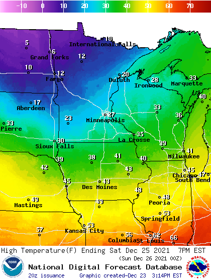
Christmas eve brings a mix of sun and a few clouds. Highs should push well into the 40s across southern Minnesota, with 50 degrees possible along the I-90 corridor.
Turn Up Your Support
MPR News helps you turn down the noise and build shared understanding. Turn up your support for this public resource and keep trusted journalism accessible to all.

Good travel weather through Christmas day
Overall travel weather looks good across Minnesota through Christmas day. A few light rain or snow showers may cross far northern Minnesota Friday. A chance of light snow visits north-central Minnesota later on Christmas day. Other than that our weather looks quiet through Saturday.
Highs on Christmas day will be cooler, with 20s and teens across most of Minnesota.

Snow chance Sunday and Monday
Most forecast models have been in flux about a snow chance later this weekend. The latest trends suggest a potentially significant snow event Sunday and Monday favoring areas from the Twin Cities northward.
NOAA’s GFS model shows similar solutions with the Canadian and European models and develops a large area of snow covering most of Minnesota Sunday and Monday.

Very early snowfall totals suggests significantly plowable snow for most of Minnesota by Monday. Here’s the early European model output.

So have a great Christmas holiday! But keep an eye on the potential for snow on your post-Christmas travels Sunday and Monday.


