Snowy Friday: 8-12 inches in western Minnesota; 1-4 inches across Twin Cities
Snow develops in western Minnesota overnight and moves into Twin Cities Friday morning

Go Deeper.
Create an account or log in to save stories.
Like this?
Thanks for liking this story! We have added it to a list of your favorite stories.
Here comes Minnesota’s next winter storm.
A potent Alberta clipper-type system is still on track to dump heavy snowfall across western and southwestern Minnesota Friday. Snowfall totals could exceed a foot under the heaviest snow bands in parts of southwestern Minnesota.
The Twin Cities will ride the eastern edge of the snow zone. This means a snowfall gradient that will produce the heaviest snows in the southwestern Twin Cities area, with generally lighter totals in the northeastern metro.
Let’s break down the inbound storm system and what we can expect Friday.
Turn Up Your Support
MPR News helps you turn down the noise and build shared understanding. Turn up your support for this public resource and keep trusted journalism accessible to all.
The system and snowfall timing
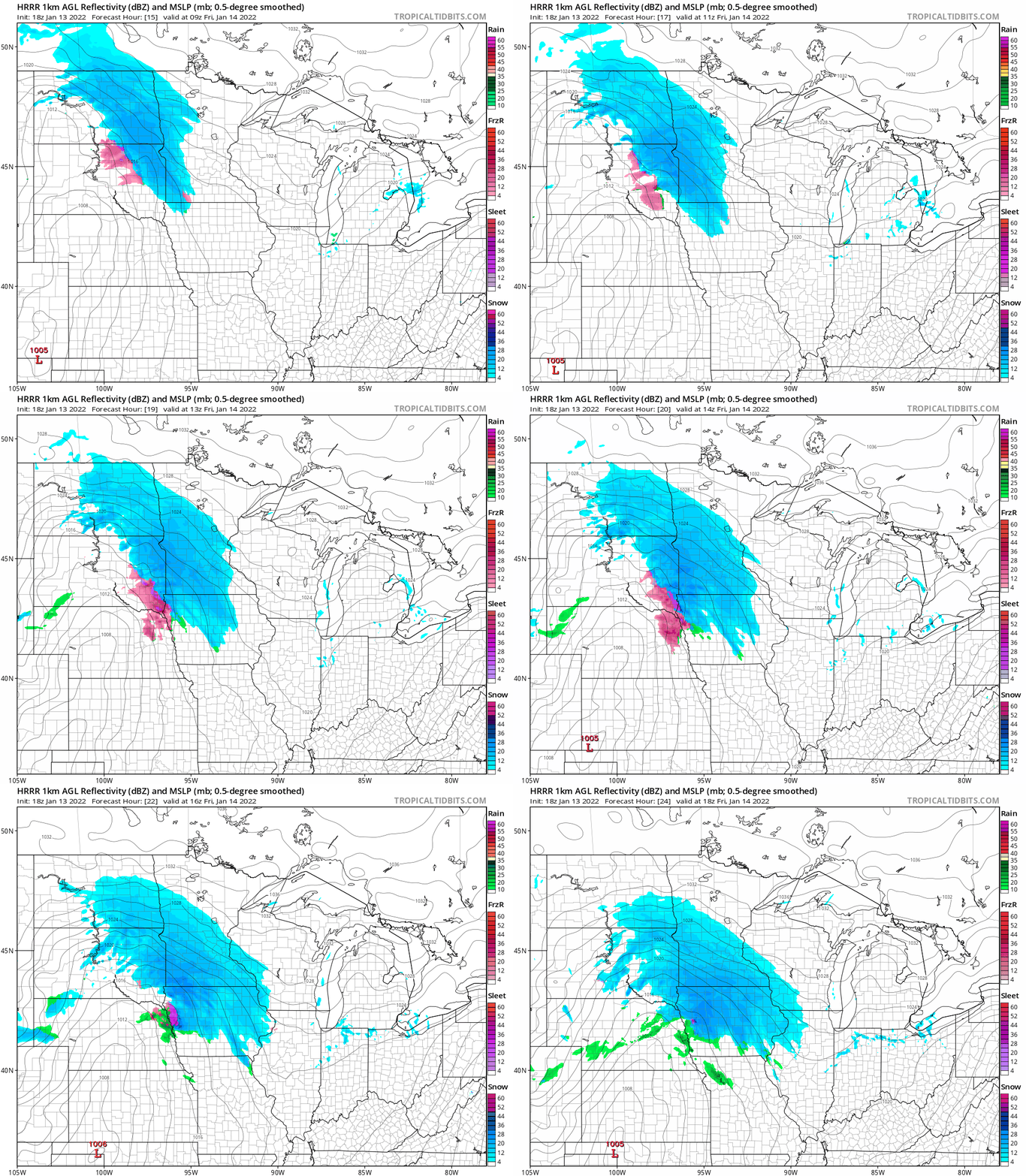
The system will push snow into western Minnesota starting after midnight. Snowfall will spread southeast across Minnesota overnight, likely reaching the Twin Cities between about 6 to 9 a.m. Friday.
The National Oceanic and Atmospheric Administration’s latest midday (18Z) High-Resolution Rapid Refresh model shows the snow zone spreading southeast between 3 a.m. and noon Friday.

The heaviest snowfall rates (around 1 inch per hour) will blanket southwestern Minnesota Friday.
Snowfall totals
Thursday’s morning and midday forecast model runs continue to lay the heaviest snow zone out across western and southwestern Minnesota. A zone of 6 to 12 inches still looks likely mainly southwest of the Minnesota River.

This will be more of a glancing blow for the Twin Cities.
It appears to me drier air to the northeast will limit snowfall in the northeast sections of the Twin Cities, where an inch or less may fall. Most of the Twin Cities will likely end up between 1 and 3 inches of snow, with the best chance for 4 inches in the southwestern areas of the Twin Cities.
NOAA’s North American Mesoscale Forecast System 3 km model paints what looks like a reasonable blend of forecast model snowfall totals for Friday.

Travel conditions
The worst travel conditions will occur in western and southwestern Minnesota Friday. Winter storm warnings are in effect from midnight Thursday through midnight Saturday.
Including the cities of Morris, Madison, Benson, Montevideo, Granite Falls, Redwood Falls, New Ulm, St James, and Fairmont
245 AM CST Thu Jan 13 2022
...WINTER STORM WARNING IN EFFECT FROM MIDNIGHT TONIGHT TO MIDNIGHT CST FRIDAY NIGHT...
* WHAT...Heavy snow expected. Total snow accumulations of 7 to 10 inches. Snowfall rates exceeding 1 inch per hour possible.
* WHERE...Portions of south central, southwest and west central Minnesota.
* WHEN...From midnight tonight to midnight CST Friday night.
* IMPACTS...Travel could be very difficult. Patchy blowing snow could significantly reduce visibility. The hazardous conditions could impact the morning and evening commute.
Here’s a look at the most likely snowfall timing around Minnesota.

Light snow likely arrives in the Twin Cities during morning rush hours and continues most of the day. The worst travel for the Twin Cities will likely be from midday through the afternoon rush hours.


