A summery Saturday; showers and thunderstorms taper off by late morning
Dew points creep up this afternoon
Go Deeper.
Create an account or log in to save stories.
Like this?
Thanks for liking this story! We have added it to a list of your favorite stories.
Areas of rain with embedded thunderstorms covered most of the eastern half of Minnesota plus western Wisconsin early Saturday morning. Northwestern Minnesota has some scattered showers.
The rain activity is moving eastward, and it will move out of most areas by midday. There could be a few lingering showers and thunderstorms in far northeastern Minnesota and far northwestern Wisconsin Saturday afternoon.
Additional showers and thunderstorms are expected to develop over eastern sections of South Dakota and North Dakota Saturday evening, then move into Minnesota and western Wisconsin overnight Saturday night and linger into Sunday morning in eastern Minnesota and western Wisconsin.
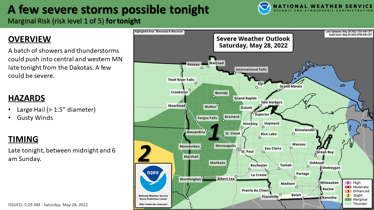
The NWS Storm Prediction Center shows a marginal risk of severe weather Saturday and Saturday night in the dark-green shaded area that includes much of western Minnesota and parts of central Minnesota:
Turn Up Your Support
MPR News helps you turn down the noise and build shared understanding. Turn up your support for this public resource and keep trusted journalism accessible to all.

Marginal risk means that an isolated severe thunderstorm is possible. Saturday night ends at 7 a.m. Sunday in NWS lingo, and the severe weather chance in some areas is mainly after midnight Saturday night.
You can hear updated weather information for Minnesota and western Wisconsin on the Minnesota Public Radio News network, and you can see updated weather info on the MPR News live weather blog.
I’ll have info on higher severe weather potential Sunday afternoon and Sunday night on the new Updraft blog that will post around 10:20 a.m. today.
Saturday highs and dew points
Our average Twin Cities high temperature is 73 degrees on May 28. Twin Cities metro area temps are forecast to reach the mid to upper 80s this Saturday. High temps will be in the 80s in roughly the southern half of Minnesota Saturday afternoon, with mainly 70s in northwestern Minnesota and western Wisconsin:

Northeastern Minnesota will have a mix of 60s and upper 50s.
Saturday afternoon dew points will rise into the 50s in much of Minnesota, with sticky lower 60s in the southwest:

Programming note
You can hear my live weather updates on MPR News at 7:35 a.m., 9:35 a.m. and 4:39 p.m. each Saturday and Sunday.


