Breezy Monday with frosty nights ahead for many
Dry weather persists through the week

Go Deeper.
Create an account or log in to save stories.
Like this?
Thanks for liking this story! We have added it to a list of your favorite stories.
The first half of this week will be cool and below normal with frost possible in many areas Monday and Tuesday nights. A warmup develops later this week into the weekend with 70s returning for southern Minnesota.
Cool with frost possible ahead
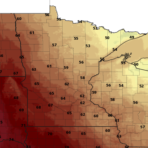
It’ll be a breezy, cool Monday. Winds will blow at 10-25 mph from the northwest through the day Monday. Wind gusts will be in the 20-30 mph range.

Highs will only be in the low 60s south to just around 50 in northern Minnesota.

A large, chilly area of high pressure is sliding in straight from the north out of Canada. It will give us lots of sunshine and lighten up the wind but also make for a couple of very chilly nights.
Turn Up Your Support
MPR News helps you turn down the noise and build shared understanding. Turn up your support for this public resource and keep trusted journalism accessible to all.

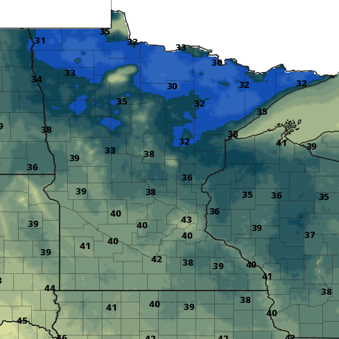
Low temperatures Monday night into early Tuesday will bring frost to much of the northern half of Minnesota into northwestern Wisconsin.

Tuesday night into early Wednesday looks to be the coldest period. Widespread frost will cover much of northern and eastern Minnesota, excluding just the Twin Cities area.
Northeastern Minnesota will see a hard freeze with temperatures slipping into the mid to upper 20s.

Hurricane Ian
Ian became a hurricane Sunday night and is forecast to become a major hurricane, which means a Category 3 or higher Monday. Hurricane Ian will hit Cuba Monday night with maximum sustained wind speeds 120 mph to 132 mph, making it a Category 3 or 4 hurricane.

After crossing Cuba, Ian will continue to strengthen in the open waters between Cuba and Florida as a solid category 4 hurricane with maximum sustained wind speeds of 135 to 140 mph.
Ian is then forecast to strike somewhere along the west central coast of Florida (potentially around Fort Myers or Tampa) as a Category 3 storm with maximum sustained wind speeds near 115 mph and gusts of up to 135 to 140 mph.


