Late summerlike November warmth smashes records; big changes ahead
Record high and overnight low temperatures through tonight

Go Deeper.
Create an account or log in to save stories.
Like this?
Thanks for liking this story! We have added it to a list of your favorite stories.
Wednesday’s weather across Minnesota is perfectly average. For Labor Day weekend.
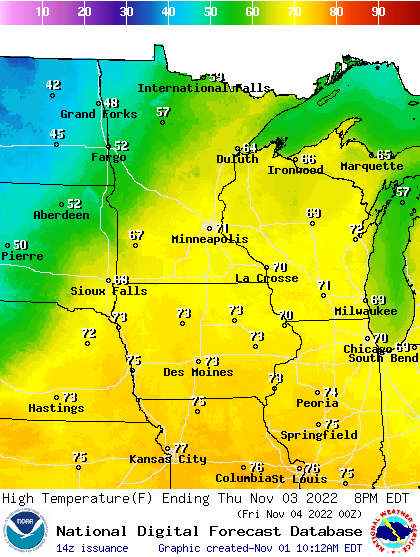
Temperatures at or above 70 degrees push all the way north to the Canadian border Wednesday. (See the image above.) The record warm air mass is toppling dozens of high and low-temperature records across our region.
In the Twin Cities, we’ve already smashed the previous Nov. 2 high-temperature record of 72 degrees set in 1978 as of this post.
For perspective, the average high temperature in the Twin Cities on Nov. 2 is 49 degrees. So Wednesday is running a good 25 degrees warmer than average across Minnesota.
Turn Up Your Support
MPR News helps you turn down the noise and build shared understanding. Turn up your support for this public resource and keep trusted journalism accessible to all.
We’ll also likely set a record warm overnight minimum temperatures for Thursday morning. The record warm minimum is 59 degrees set in 1956.
We’ll likely bottom out somewhere near 59 degrees in the Twin Cities tonight. That’s 20 degrees above our average high temperature for this time of year!

Warm again Thursday
Thursday brings another day of near-record warmth to eastern Minnesota. Highs will top out in the 70s again. The record high for the Twin Cities on Nov. 3 is 75 degrees set in 2020.

Rain chances shifting southeast
Our next chance for rain arrives Thursday night through Saturday, but the system is trending southeast. That puts the Twin Cities on the drier western edge of the storm.

But heavy, meaningful rains are likely in southeastern Minnesota and Wisconsin.

There are signs of more possible rain, and snow, next week.
Stay tuned.


