A pleasant Sunday; Plowable snow will slow commutes on Tuesday
A look at Tuesday/Tuesday night snow potential
Go Deeper.
Create an account or log in to save stories.
Like this?
Thanks for liking this story! We have added it to a list of your favorite stories.
Weather isn’t expected to interfere with Sunday travel plans in most of Minnesota and western Wisconsin. There have been some areas of fog in northwestern Minnesota this morning, but that fog should thin out as temperatures rise today.
Temperature trends
Sunday highs will be in the 30s across much of Minnesota and western Wisconsin. Some locations in northwestern Minnesota will top out in the upper 20s, and some spots in the Twin Cities metro area and southern Minnesota could touch 40 degrees. Our average Twin Cities high is 36 degrees this time of year.
Monday highs will reach the lower 40s in the metro area and southern Minnesota, with 30s elsewhere:

Twin Cities metro area highs are projected to be in the lower 30s on Tuesday, followed by lower 20s Wednesday then upper 20s Thursday and mid-30s on Friday.
Turn Up Your Support
MPR News helps you turn down the noise and build shared understanding. Turn up your support for this public resource and keep trusted journalism accessible to all.
Monday snow chances north
There’s a chance of light snow in roughly the northern third of Minnesota Monday and into Monday night. The National Oceanic and Atmospheric Administration’s North American Mesoscale (NAM) forecast model shows the potential precipitation pattern from 5 a.m. Monday to 11 p.m. Monday:

Plowable snow in many areas Tuesday, Tuesday night
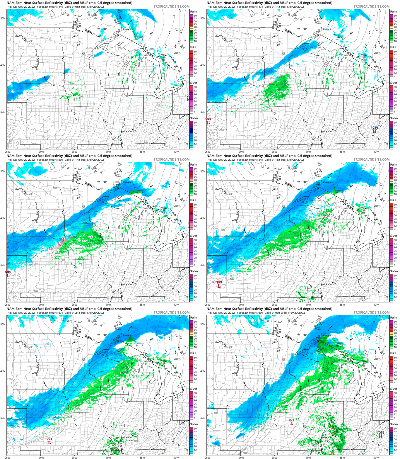
A low pressure system is expected to spread a swath of snow from southwestern and south-central Minnesota into central Minnesota, the Twin Cities metro area and portions of northeastern Minnesota and western Wisconsin Tuesday and Tuesday night.
NOAA’s North American Mesoscale forecast model shows the potential precipitation pattern from 2 a.m. Tuesday to 6 p.m. Tuesday:

Plowable snow is expected in many areas:

Snow can vary quite a bit over relatively short distances with this type of storm track. The odds of 6 inches or more of snow favor northwestern Wisconsin and a portion of east-central Minnesota:

A winter storm watch (blue in the left panel above) has been posted from Chisago County to southern St. Louis County in Minnesota plus much of northwestern Wisconsin and a part of west-central Wisconsin.
Here are details of the winter storm watch in Chisago County and points to the east:
URGENT - WINTER WEATHER MESSAGE National Weather Service Twin Cities/Chanhassen MN 142 AM CST Sun Nov 27 2022 MNZ053-WIZ014>016-271545- /O.NEW.KMPX.WS.A.0003.221129T1200Z-221130T1200Z/ Chisago-Polk-Barron-Rusk- Including the cities of Center City, Osceola, Rice Lake, and Ladysmith 142 AM CST Sun Nov 27 2022 ...WINTER STORM WATCH IN EFFECT FROM TUESDAY MORNING THROUGH LATE TUESDAY NIGHT... * WHAT...Heavy snow possible. Total snow accumulations of 4 to 7 inches possible. * WHERE...In Minnesota, Chisago County. In Wisconsin, Polk, Barron and Rusk Counties. * WHEN...From Tuesday morning through late Tuesday night. * IMPACTS...Plan on slippery road conditions. The hazardous conditions could impact the morning and evening commute. PRECAUTIONARY/PREPAREDNESS ACTIONS... Monitor the latest forecasts for updates on this situation.
Here’s a look at the northern extent of the winter storm watch:

As new forecast model info arrives today, the NWS may add more counties to the winter storm watch.
The Duluth NWS office has posted probabilities for 4 and 6 inch snow totals for various locations for Tuesday through Tuesday night.

We have updated weather information for Minnesota and western Wisconsin on the Minnesota Public Radio News network, and on the MPR News live weather blog.
Programming note
You can hear my live weather updates on MPR News at 7:35 a.m., 9:35 a.m. and 4:39 p.m. Saturday and Sunday.


