I-90 corridor snow may run 4-6 inches; wintry mix Saturday
1 inch or less expected in much of the Twin Cities region
Go Deeper.
Create an account or log in to save stories.
Like this?
Thanks for liking this story! We have added it to a list of your favorite stories.
A low-pressure system will pass to our south late Thursday into Friday morning, spinning moisture over much of southern Minnesota and southern Wisconsin.
The National Oceanic and Atmospheric Administration’s North American Mesoscale (NAM) forecast model shows the potential precipitation pattern from 5 p.m. Thursday to 5 p.m. Friday:

The precipitation could begin as freezing drizzle in some areas, then transition to snow. The highest snow totals Thursday evening through Friday morning area expected to be in far southern Minnesota, where some spots could end up with 4 to 6 inches:

Twin Cities metro area totals Thursday night into early Friday are expected to be 1 inch or less, but far southern portions of Scott County and Dakota County could see a bit more than 1 inch.
Turn Up Your Support
MPR News helps you turn down the noise and build shared understanding. Turn up your support for this public resource and keep trusted journalism accessible to all.
Winter weather advisories begin Thursday evening in the southern Minnesota counties shaded blue:

The winter weather advisory begins at 6 p.m. Thursday and ends at 6 a.m. Friday in far southwestern Minnesota.
The winter weather advisory begins at 9 p.m. Thursday in the remainder of the blue-shaded southern Minnesota counties, ending at 9 a.m., Friday in south-central Minnesota and at noon Friday in southeastern Minnesota.
The winter weather advisory starts at midnight Thursday night in southwestern Wisconsin and continues until 3 p.m. on Friday.
Here are details of the winter weather advisory that begins at 9 p.m. Thursday in south-central Minnesota:
URGENT - WINTER WEATHER MESSAGE National Weather Service Twin Cities/Chanhassen MN 1117 AM CST Thu Dec 8 2022 MNZ073>078-082>085-091>093-090130- /O.EXT.KMPX.WW.Y.0023.221209T0300Z-221209T1500Z/ Redwood-Brown-Nicollet-Le Sueur-Rice-Goodhue-Watonwan-Blue Earth- Waseca-Steele-Martin-Faribault-Freeborn- Including the cities of Redwood Falls, New Ulm, St Peter, Le Sueur, Faribault, Red Wing, St James, Mankato, Waseca, Owatonna, Fairmont, Blue Earth, and Albert Lea 1117 AM CST Thu Dec 8 2022 ...WINTER WEATHER ADVISORY NOW IN EFFECT FROM 9 PM THIS EVENING TO 9 AM CST FRIDAY... * WHAT...Snow, heavy at times, along I-90. Total snow accumulations of 2 to 5 inches with locally higher amounts possible near the Iowa border. * WHERE...Portions of south central, southeast and southwest Minnesota. * WHEN...From 9 PM this evening to 9 AM CST Friday. * IMPACTS...Plan on slippery road conditions. The hazardous conditions could impact the morning commute. PRECAUTIONARY/PREPAREDNESS ACTIONS... Slow down and use caution while traveling. The latest road conditions for the state you are calling from can be obtained by calling 5 1 1.
You can find updated weather information for Minnesota and western Wisconsin on the Minnesota Public Radio News network, and on the MPR News live weather blog.
Saturday mix possible
Southern and central Minnesota and west-central Wisconsin could see periods of drizzle, light freezing drizzle and light snow Saturday morning and early Saturday afternoon.
The northern third of Minnesota, plus northwestern Wisconsin, may see periods of light snow on Saturday. Check forecast updates.
Weekend temps
Our average Twin Cities high temperature is 31 degrees on Dec. 10. Metro area highs will be in the mid 30s this Saturday. Most of Minnesota and western Wisconsin will see Saturday highs in the 30s:

Saturday afternoon wind chill temps will be mainly in the 20s:

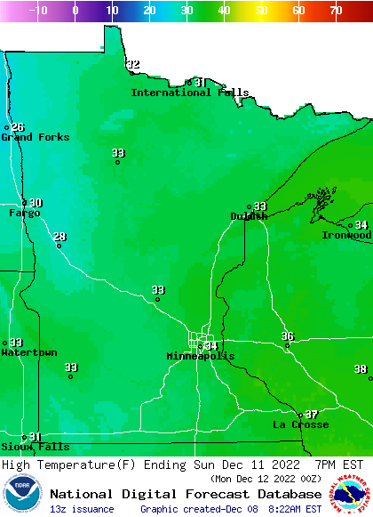
Sunday high temps will reach the 30s in most areas, with 20s in northwestern Minnesota:

Winds will be very light on Sunday.
Programming note
You can hear my live weather updates on MPR News at 7:35 a.m., 9:35 a.m. and 4:39 p.m. Saturday and Sunday.


