Blizzard conditions on the way for many Thursday into Friday
Blowing snow accompanied by dangerous cold into Friday night

Go Deeper.
Create an account or log in to save stories.
Like this?
Thanks for liking this story! We have added it to a list of your favorite stories.
Updated 10 a.m.
Gusty winds replace the falling snow Thursday. Winds will increase to 20-25 mph in southwestern Minnesota, gusting to 30 mph. Winds Friday will be even stronger. Wind chills will range from minus 30 to minus 45 early Thursday and Friday mornings.
Blizzard conditions develop in many areas
Many areas saw substantial new snowfall. Totals ranged from about 4 to 8 inches around the Twin Cities and central Minnesota. Portions of the North Shore around Tofte and Lutsen saw a foot. Here are the totals we have in so far:

The map below is a broader, smoothed out view of snowfall totals. You can see some of the highest were in the Twin Cities area. The higher amounts around the North Shore were not yet reflected in this analysis from overnight.

Snow showers will linger into the Arrowhead region Thursday with additional accumulations. We could see some more scattered light snow showers Friday, but the bigger issue will be blowing snow.
Turn Up Your Support
MPR News helps you turn down the noise and build shared understanding. Turn up your support for this public resource and keep trusted journalism accessible to all.

Additional snowfall will be confined to mostly far eastern portions of Minnesota.

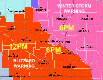
Blizzard warnings take effect midday into the afternoon and evening for a large chunk of Minnesota as winds increase, decreasing visibility as a result of blowing snow.

Wind gusts will be highest in southwestern Minnesota Thursday and range from 25 to 35 mph.

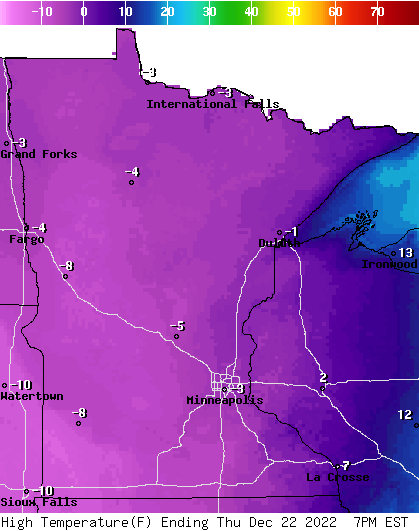
High temperatures Thursday will remain below zero statewide, all day long.

Wind chill values will be dangerously cold at minus 25 to minus 40 degrees. Exposed skin can freeze in just minutes in those conditions.

Winds increase even more on Friday with gusts as high as 40 mph in southern Minnesota but potentially over 50 mph along the North Shore.

Wind chills Friday morning again will be dangerously cold, potentially even colder.

Temperatures remain below zero and very cold into Sunday morning. By Sunday afternoon, high temperatures will climb above zero across southern. This frigid, arctic air departs finally after Sunday allowing warmer air to return to the region.

Highs by Wednesday could climb above freezing for much of southern Minnesota.


