Large, messy winter storm getting closer

Go Deeper.
Create an account or log in to save stories.
Like this?
Thanks for liking this story! We have added it to a list of your favorite stories.
Monday is beginning with low clouds and patchy fog. Afternoon high temperatures will be in the teens in northwestern Minnesota and 20s elsewhere. The Twin Cities should reach about 27 with a very light breeze.
High impact winter storm coming
A soggy, March-like winter storm is plodding our way from Colorado on Monday. A light wintry mix will break out across southern Minnesota Monday afternoon. Snow will develop farther north Monday night and Tuesday.
This storm is a huge weather-maker with freezing rain, sleet and heavy snow from the Central Plains to the Upper Midwest and a severe weather outbreak possible in the South:

Here are the winter weather warnings and advisories that have been posted as of Monday morning:
Turn Up Your Support
MPR News helps you turn down the noise and build shared understanding. Turn up your support for this public resource and keep trusted journalism accessible to all.

Ice Storm
A wintry mix of freezing rain and sleet will grow into an ice storm in south central Minnesota by Monday night. An ice storm warning goes into effect at 6 p.m. on Monday and will continue through Tuesday for the areas shown, including Mankato, Waseca, Owatonna, Jackson, Fairmont, Albert Lea and Austin. Ice of around a quarter of an inch or more should be expected by Tuesday. Travel will likely become difficult. Power lines will be at risk. Lesser amounts of freezing rain and sleet are likely for southeastern Minnesota including Rochester.
Heavy, wet snow
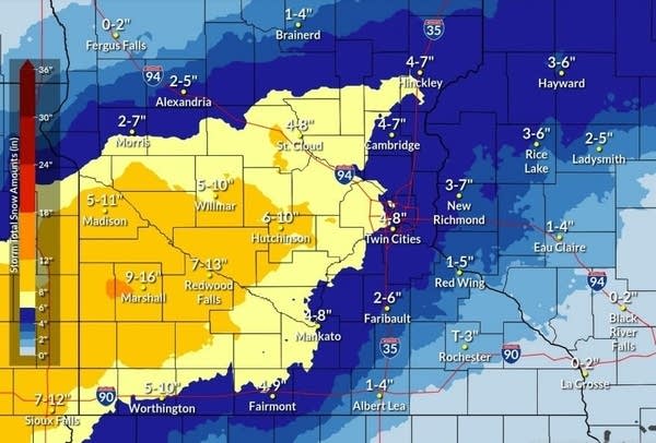
Snow will be the main weather element on the north side of the storm. Heavy, rather wet snow will arrive in southwestern Minnesota Monday night and spread across central Minnesota into northwestern Wisconsin on Tuesday. Snow should fall the heaviest on Tuesday. The winter storm warnings shown above go into effect at a variety of times, generally beginning Monday night.
Many areas generally west of the Twin Cities are likely to pick up around 8 to 12 inches of snow by Wednesday. Heaviest snowfalls are likely to be in southwest and west central Minnesota where most areas will get a foot or more. The Highest amounts seem likely for the Buffalo Ridge area of southwestern Minnesota where amounts could reach about 20 inches.
Lesser amounts of snow are likely north of the winter storm warning. Northwestern Minnesota will remain storm-free.

Wintry mix
A wintry mix of freezing rain, sleet and snow will be likely along the border between the ice and snow. This area is likely to shift around with time and gradually change over to all snow as the storm progresses. Snow will taper off and probably end on Wednesday.

Twin Cities
The Twin Cities area will have a cloudy Monday with morning fog and maybe some flurries. A wintry mix is likely by late Monday afternoon or evening, especially on the south side. The winter storm warning is scheduled to begin at 9 p.m. and continue through Tuesday until midnight. Light snow will continue into Wednesday. Total snowfalls in the metro area should be something around 6 to 8 inches with the highest amounts on the west side.
Wind not a factor
Winds will be rather light with this storm. Along with the wetness of the snow, the lightness of the wind will prevent any drifting.
No arctic plunge this time
There is no arctic air waiting to pummel us after the storm passes. High temperatures on Thursday will be mostly in the teens to around 20.

And we should moderate a bit by Saturday.


