

Air quality alert extended through Wednesday; fog, smog, mild temps
Go Deeper.
Create an account or log in to save stories.
Like this?
Thanks for liking this story! We have added it to a list of your favorite stories.
Updated 11:50 a.m.
The air quality alert across Minnesota has been extended through 6 p.m. Wednesday, with air in some parts of the Twin Cities and Moorhead, Minn., considered “unhealthy.”
The Minnesota Pollution Control Agency says Minnesota hasn’t seen a winter air quality problem this bad since Dec. 21, 2005.
Tuesday will be mild again with highs in the 30s and 20s. Snow showers with a possible wintry mix move through central Minnesota Tuesday night.
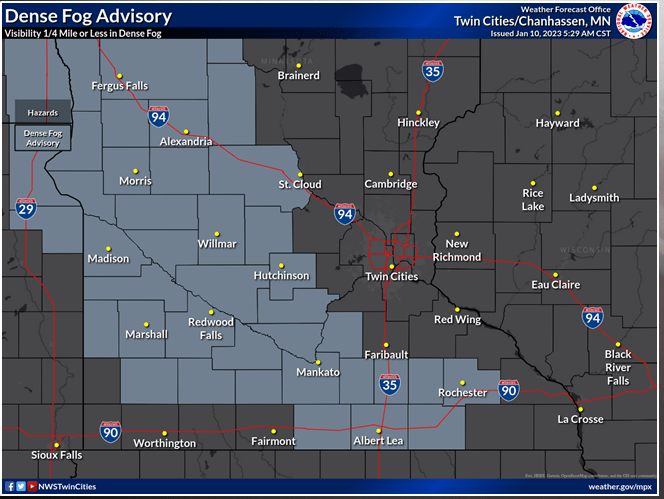
Fog and smog
We have pretty widespread freezing fog Tuesday morning across Minnesota but it’s especially dense in western Minnesota. A dense fog advisory is posted through noon for those areas. Expect areas of fog to linger into Tuesday and thicken up again into early Wednesday.
Turn Up Your Support
MPR News helps you turn down the noise and build shared understanding. Turn up your support for this public resource and keep trusted journalism accessible to all.

For similar reasons we have fog, we have poor air quality.
Light winds and a temperature inversion (warmer air layered over colder air) is allowing pollutants to build up in the lower most layers of the atmosphere, near the surface.
An air quality alert across Minnesota has been extended through 6 p.m. Wednesday, with air in some parts of the Twin Cities and Moorhead, Minn., considered “unhealthy.” That means children, the elderly and people with respiratory or heart problems should avoid prolonged exertion, according to the Minnesota Pollution Control Agency.
Conditions are expected to improve Wednesday evening, the MPCA added. It will be especially better Thursday and Friday as colder, drier northwest air moves in.
Snow showers Tuesday night then cooler
A quickly moving system will bring a wintry mix of possible freezing precipitation and snow showers Tuesday night across much of central Minnesota.

There could be a light, icy coating in parts of Minnesota Tuesday night as some temperatures aloft will be above freezing but surface temperatures will be largely subfreezing.

Most of central Minnesota will see a coating of snow but there could be a narrow area of slightly higher totals of 1 to 2 inches.

The models are all over the map, however, on where this narrow area develops, so be aware that you could see more or less depending on where it sets up overnight.

After Wednesday temperatures will cool off temporarily into the 20s and teens Thursday and Friday. Importantly, this temperature and wind shift will clear out the foggy and smoggy conditions.
