

Weekend weather: Temps set to rebound into the 20s, 30s
Plenty of snow on the ground for winter fun
Go Deeper.
Create an account or log in to save stories.
Like this?
Thanks for liking this story! We have added it to a list of your favorite stories.
Temperatures across most of Minnesota were still below zero at 1 p.m. Friday. A few spots in far southern Minnesota had crept slightly above zero.
You’ll probably be happy to know that temperatures will slowly rise Friday evening and overnight Friday night.
Weekend temps
Temperatures at 9 a.m. Saturday will range from lower 20s in southwestern Minnesota to single digits above zero in the northeast:
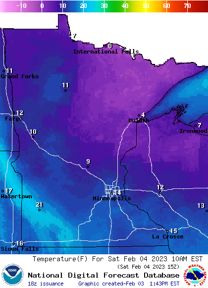
Saturday high temps reach the 30s in parts of western Minnesota and most of southern Minnesota, with mainly 20s elsewhere:
Turn Up Your Support
MPR News helps you turn down the noise and build shared understanding. Turn up your support for this public resource and keep trusted journalism accessible to all.

Many spots in the Twin Cities metro area will reach the lower 30s Saturday afternoon. Our average Twin Cities high temp is 24 degrees this time of year.
Sunday highs will be in the 30s in the metro area, southern Minnesota and west-central Wisconsin, with mainly 20s elsewhere:

Mainly dry
Parts of northeastern Minnesota could see a few light snow showers Friday evening.
Saturday looks dry in most of Minnesota and western Wisconsin. A few patchy light snow showers are possible in far northern Minnesota and northwestern Wisconsin late Saturday afternoon and Saturday night/early Sunday.
The National Oceanic and Atmospheric Administration’s North American Mesoscale (NAM) forecast model shows the potential precipitation pattern from noon Saturday to 5 p.m. Sunday:
You can find updated weather information for Minnesota and western Wisconsin on the Minnesota Public Radio News network, and on the MPR News live weather blog.
Plenty of snow cover for winter fun
If you weekend plans include sledding, cross-country skiing or snowboarding, there’s plenty of snow in the ground across most of Minnesota.
Here’s the weekly snow depth map from the Minnesota Department of Natural Resources:

The official Twin Cities snow depth at Minneapolis-St. Paul International Airport is 10 inches right now, Some spots in southern Scott County have more than 15 inches of snow cover.
The purple shaded areas from Pine County through northeastern Minnesota have snow depths of 18 inches or more. The light-purple shaded areas in northeastern Minnesota have 24 to 30 inches of snow cover.
Programming note
You can hear my live weather updates on MPR News at 7:35 a.m., 9:35 a.m. and 4:39 p.m. Saturday and Sunday.