

Blizzard winds, heavy snow set to whack southern Minnesota overnight
Twin Cities region expected to get another 8-11 inches
Go Deeper.
Create an account or log in to save stories.
Like this?
Thanks for liking this story! We have added it to a list of your favorite stories.
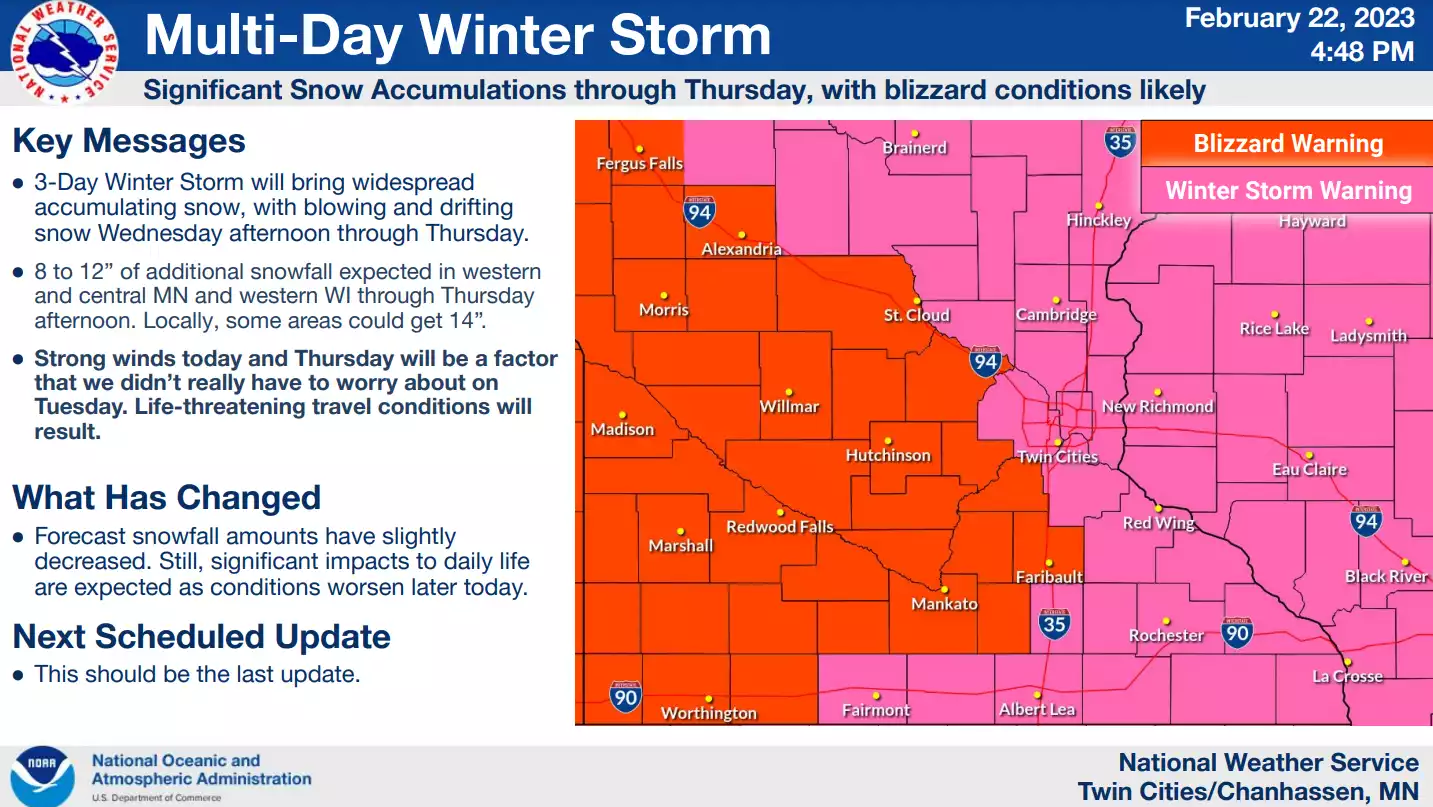
The main body of our multiday snow system works across Minnesota overnight into Thursday morning.
The storm’s second wave came in slowly late Wednesday afternoon, but forecast models have always suggested the peak snowfall rates and highest winds will occur Wednesday night into early Thursday morning.

Blizzard warnings remain in effect for most of southern Minnesota, including Twin Cities outer ring counties to the west and south.
Including the cities of Monticello, Hutchinson, Gaylord, Chanhassen, Chaska, Victoria, Shakopee, St Peter, Le Sueur, Faribault, Mankato, Waseca, Owatonna, Fairmont, Blue Earth, and Albert Lea
1258 PM CST Wed Feb 22 2023
..BLIZZARD WARNING REMAINS IN EFFECT UNTIL NOON CST THURSDAY...
* WHAT...Blizzard conditions. Additional snow accumulations of 8 to 12 inches. Winds gusting as high as 45 mph.
* WHERE...Portions of central, east central and south central Minnesota.
* WHEN...Until noon CST Thursday.
* IMPACTS...Travel could be very difficult to impossible. Widespread blowing snow could significantly reduce visibility. The hazardous conditions could impact the morning or evening commute.
Snowfall overnight
Weather models, including the National Oceanic and Atmospheric Administration’s NAM 3 km system, show the heaviest snowfall moving across Minnesota between about 10 p.m. Wednesday and 7 a.m. Thursday.
Turn Up Your Support
MPR News helps you turn down the noise and build shared understanding. Turn up your support for this public resource and keep trusted journalism accessible to all.
The loop below runs between 6 p.m. Wednesday and noon Thursday:

Additional snowfall
The remaining overnight and morning snowfall will add up to significant totals across southern and central Minnesota.

Here’s a wider look at additional accumulations for Minnesota.

High winds
One element that is different from Tuesday’s snow is the addition of higher winds overnight into Thursday. Wind gusts of 40 mph will whip snow around through much of Thursday.

Expect a very difficult rush hour Thursday morning before snow and wind decrease later Thursday.