Chillier Monday then warming up with a late week storm
Below normal temperatures Monday statewide

Go Deeper.
Create an account or log in to save stories.
Like this?
Thanks for liking this story! We have added it to a list of your favorite stories.
We start the week chillier behind the weekend storm system. Highs will be in the 20s to low 30s Monday, more than 10 degrees below normal for some. We have a midweek warm up then a potential big storm Thursday into Friday.
Cooler Monday into Tuesday then a warm up
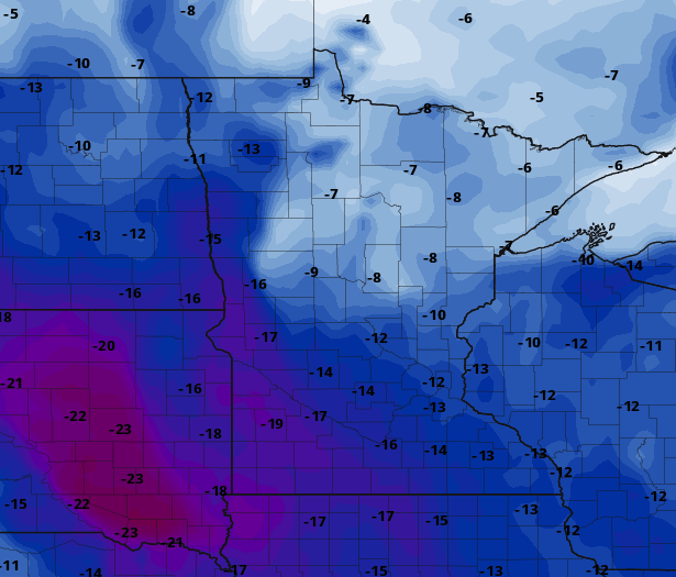
Cooler air is in place for the start of the week behind the weekend snow storm. We’ll see high temperatures mainly in the 20s to low 30s Monday afternoon which is about 10 degrees below normal to even almost 20 degrees cooler than normal in the western part of the state.

With at least partially clearing skies, it will be another cold night Monday night into early Tuesday. Temps will dip into the single digits and teens.

We are then poised for a midweek warm up with highs in the 40s for many areas Wednesday and once again Thursday for southeast Minnesota.

St. Patty’s storm Thursday into Friday
Our next big storm system will be slamming into California Tuesday, bringing more flooding there and then pushing east into Minnesota late Thursday into Friday.

The extent of warm air, and specific storm track are still a bit up in the air but regardless, it appears Minnesota will be soaked with up to one inch or more of liquid equivalent precipitation and the potential for some heavy snow too. As usual, stay tuned.
Turn Up Your Support
MPR News helps you turn down the noise and build shared understanding. Turn up your support for this public resource and keep trusted journalism accessible to all.


