Winter storm warning northwest; mostly rain for Twin Cities
Accumulating snow north

Go Deeper.
Create an account or log in to save stories.
Like this?
Thanks for liking this story! We have added it to a list of your favorite stories.
Our exceedingly wet cold-season weather pattern continues. Our next weather system brings a mix of rain and snow to Minnesota into Wednesday.
Winter storm warnings are up for a big chunk of northwestern Minnesota into Wednesday.
Including the cities of Crookston, East Grand Forks, Ada, Twin Valley, Halstad, Moorhead, Baudette, Red Lake, Redby, Ponemah, Thief River Falls, Red Lake Falls, Fosston, Fertile, McIntosh, Erskine, Bagley, Clearbrook, Bemidji, Mahnomen, Naytahwaush, Waubun, Alida, Ebro, Lake Itasca, Long Lost Lake, Lower Rice Lake, Roy Lake, Upper Rice Lake, Finley, Hope, Mayville, Hillsboro, Hatton, Portland, Valley City, Fargo, Lisbon, Enderlin, Gwinner, Milnor, Forman, Rutland, and Wahpeton
350 AM CDT Tue Mar 21 2023
...WINTER STORM WARNING IN EFFECT FROM 4 PM THIS AFTERNOON TO 7 AM CDT WEDNESDAY...
* WHAT...Heavy snow expected. Total snow accumulations of 4 to 7 inches. Snowfall rates could reach 1 to 2 inches per hour. Higher totals are supported, but are not expected to be widespread. Patchy blowing snow is possible.
* WHERE...Portions of north central, northwest and west central Minnesota and southeast North Dakota.
* WHEN...From 4 PM this afternoon to 7 AM CDT Wednesday.
* IMPACTS...Travel could be very difficult. Areas of blowing snow could significantly reduce visibility. The hazardous conditions could impact the morning or evening commute.
The system
This one is a pretty typical March low-pressure system. It is tracking a little farther north than the past few storms, through central and northeastern Minnesota.
That puts the Twin Cities on the warmer (rainy) southern side of the system, but it will be cold enough for a mix of ice and snow in central and northern Minnesota.
Turn Up Your Support
MPR News helps you turn down the noise and build shared understanding. Turn up your support for this public resource and keep trusted journalism accessible to all.
The National Oceanic and Atmospheric Administration’s NAM 3 km model seems to have a good handle on the rain and snow zones through Tuesday night. The main shot of rain in the Twin Cities likely arrives between about 10 p.m. and 2 a.m. overnight into Wednesday.
Check out the slightly higher modeled intensity (yellow) of some of the rain cells over the Twin Cities Tuesday night. We could have a few brief downpours!

Snow up north
In the subfreezing air up north it will be mostly snow. There may be some ice mixed in Tuesday night in central Minnesota. You can see the overall statewide snowfall projection:

Here’s a closer look at northeastern Minnesota snowfall projections:

Here’s a look at likely snowfall for northwestern Minnesota and the Red River Valley:

Milder late this week
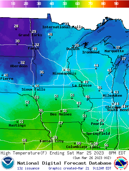
Our weather will mellow as we move toward the upcoming weekend. The European Centre for Medium-Range Weather Forecasts model suggests a mix of sun and clouds between Friday and Monday with highs in the 40s to nearly 50 degrees for southern Minnesota.
Here’s a look at highs currently forecast for Saturday:


