Spotty thunderstorms north tonight favor Twin Cities area Saturday afternoon
Rainfall coverage will be localized. Breezy and cooler Sunday.
Go Deeper.
Create an account or log in to save stories.
Like this?
Thanks for liking this story! We have added it to a list of your favorite stories.
We’re tracking a cold front dropping southward through Minnesota through Saturday.
As of this post late Friday, the front is crossing the Canadian border dropping southward. The front has sparked scattered thunderstorms this afternoon from Hallock through Roseau to Warroad, and Baudette to International Falls. The MPR interactive radar at 5:20 pm Friday is lighting up with lightning strikes late Friday afternoon from near Fargo and Bemidji to International Falls.

Expect scattered storms to gradually drift southward along the frontal zone into tonight.
Scattered storms Saturday
The front will drift southward through central Minnesota and the Twin Cities area Saturday. Scattered thunderstorms will fire along the frontal boundary favoring Saturday afternoon into the evening.
Turn Up Your Support
MPR News helps you turn down the noise and build shared understanding. Turn up your support for this public resource and keep trusted journalism accessible to all.
NOAA’s FV3 model tracks the line of storms across northern Minnesota Friday evening, then watch as spotty storms redevelop in the heat of the day Saturday afternoon around the Twin Cities and especially south.

Rainfall coverage will be spotty once again with this fairly weak cold front. If you get under a brief downpour you could pick up .25” to .50” of rainfall. There may even be some local rainfall totals over an inch under a couple of slow-moving cells. But many areas will see less than that, or miss the rain Saturday.
NOAA’s FV3 rainfall output shows the chaotic patchwork nature of likely rainfall through Saturday.

Cooler breezes Sunday
Temperatures Saturday will hover in the 80s south of the frontal zone with 70s north. Highs will be in the chilly 60s near Lake Superior.

Northerly winds behind the cool front Saturday night and Sunday will feed noticeably cooler air into Minnesota.
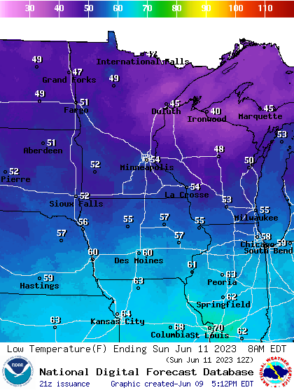
Lows Saturday night into Sunday morning will feel comfortable and you may want to open those windows. Good sleeping weather as the old timers used to say.

Highs Sunday will hover in the low to mid-70s across much of Minnesota.

There may be some minor smoke near ground level with the frontal passage Saturday evening.


