

Air quality alert into Thursday; elevated wildfire risk for eastern MN
Smoke, ozone levels rising
Go Deeper.
Create an account or log in to save stories.
Like this?
Thanks for liking this story! We have added it to a list of your favorite stories.
Here we go again.
Tuesday afternoon brought yet another air quality alert to much of Minnesota. This one is set to run through 6 a.m. Thursday. And there’s now an elevated threat of wildfires for much of eastern Minnesota, Wisconsin, and Michigan.
First our latest air quality alert for Minnesota.
This one features two different air quality threats. The alert for northern Minnesota favors increased particulate matter readings from more Canadian wildfire smoke.
Turn Up Your Support
MPR News helps you turn down the noise and build shared understanding. Turn up your support for this public resource and keep trusted journalism accessible to all.
The smoke plume drifting southward into the Upper Midwest is clearly visible from space on satellite images Tuesday from the National Oceanic and Atmospheric Administration.

In the south, elevated levels of ozone will push air quality index readings higher.
Here are details on the latest air quality alert from the Minnesota Pollution Control Agency:
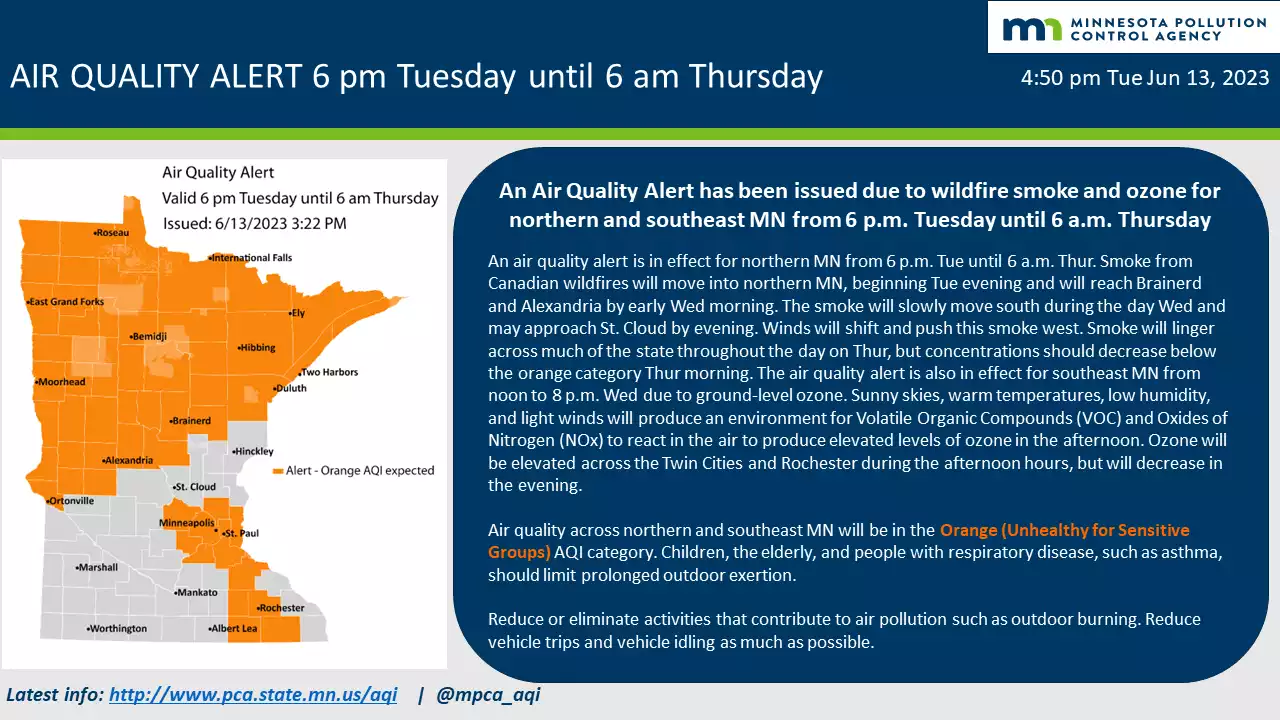
The Minnesota Pollution Control Agency (MPCA) has issued an air quality alert for northern Minnesota due to wildfire smoke, effective from 6 p.m. on Tuesday, June 13, until 6 a.m. on Thursday, June 15. The affected area includes Roseau, International Falls, Ely, Hibbing, Duluth, Two Harbors, Brainerd, Alexandria, Moorhead, Ortonville, and the tribal nations of Grand Portage, Fond du Lac, Leech Lake, Red Lake, and Mille Lacs. The alert is also in effect due to ozone for southeast Minn., effective Wednesday, June 14, from noon to 8 p.m. The affected area includes the Twin Cities, Rochester, and the tribal nation of Prairie Island.
Smoke from Canadian wildfires will move into northern Minn., beginning Tuesday evening and will reach Brainerd and Alexandria by early Wednesday morning. The smoke will slowly move south during the day Wednesday and may approach St. Cloud in the evening. In addition, light smoke may move into southeast Minn. on Wednesday evening. Winds will shift and push this smoke towards the west. Smoke will linger across much of the state throughout the day on Thursday, but concentrations should decrease below the orange category Thursday morning. In addition, sunny skies, warm temperatures, low humidity, and light winds will produce an environment for Volatile Organic Compounds (VOC) and Oxides of Nitrogen (NOx) to react in the air to produce elevated levels of ozone in the afternoon. Ozone will be elevated across the Twin Cities and Rochester during the afternoon hours, but will decrease in the evening.
Air quality levels are expected to be in the orange air quality index (AQI) category, a level that is considered unhealthy for sensitive groups, for northern and southeast Minnesota. In the orange area, sensitive groups should avoid prolonged time outdoors.
What this alert means
Air moves long distances and carries pollutants. During air quality alerts due to wildfires, the air is mixed with harmful smoke. Wildfire smoke spreads or lingers depending on the size of the fires, the wind, and the weather.
The air quality index (AQI) is color-coded. Air quality alerts are issued when the AQI is forecast to reach an unhealthy level, which includes forecasts in the orange, red, purple, and maroon categories. For a full description of each air quality category, visit airnow.gov.
Orange air quality: Unhealthy for sensitive groups
Sights and smells: In areas where air quality is in the orange AQI category due to wildfires, the sky may look hazy and residents may smell smoke even when wildfires are far away.
Health effects: This air is unhealthy for sensitive groups and pollution may aggravate heart and lung disease as well as cardiovascular and respiratory conditions. Symptoms may include chest pain, shortness of breath, wheezing, coughing, and fatigue.
What to do: People in sensitive groups are encouraged to reduce outdoor physical activities, take more breaks, or do less intense activities to reduce their exposure. People with asthma should follow their asthma action plan and keep their rescue inhaler nearby.
Elevated fire risk for eastern Minnesota
I can’t remember the last time I saw an advisory for dry fuels and fire behavior cover this much of Minnesota.

I’ve been writing for weeks now about the flash drought taking hold in Minnesota. One consequence of this rapid drought onset is that fire fuels — grasses, marsh vegetation and trees — are drying out quickly.
That means fires can spread rapidly through our area. The fuels buildup index shows elevated fuel levels across our region.

We’re used to talking about large wildfires over 1,000 acres in the west. But large and intense wildfires have also occurred in Minnesota historically. This kind of weather pattern is favorable for rapidly growing and spreading fires in eastern Minnesota.
Here’s more on the advisory from the Eastern Area Fire Environment Working Group, Milwaukee, Wis.:
Fuels and Fire Behavior Advisory Northeastern Minnesota, Wisconsin, and Michigan Date Advisory Takes Affect –
June 12, 2023
Subject: The Great Lake states of MN, WI, and MI observe significantly elevated fire risk with long-term outlooks of warmer and dryer than normal weather.
Discussion: Since mid-spring 2023, the advisory area has experienced periods of increased fire risk. The past month has seen little to no rain, causing vegetation to dry out as rainfall deficits continues to grow. The area is facing a precipitation deficit of over 3 inches and USGS monitored streamflow stations are reporting low levels at the 90th percentile.
Long-term forecasts describe warm and dry conditions throughout June. In the advisory area, summer fire seasons are typically infrequent and short-lived. However, some of the largest wildfires have happened in mid to late summer. For instance, the Wilderness Trail Fire (MI-MIS) began on June 3rd and spread quickly while showing extreme fire behavior and burning nearly 2,400 acres of jack pine in one burn period.
The main factors were low needle moisture in the pines, which continue to experience spring dip and may recover more slowly due to the overall dryness of the fire environment. Currently, suppressing and mopping up wildfires can require up to five times more energy and effort than usual.
Difference from normal conditions: Fire danger indices from both the Canadian Forest Fire Danger Rating System (CFFDRS) and National Fire Danger Rating System (NFDRS) have been reaching historic daily highs. Reports of high probabilities of ignition, rapid spread, crown fire initiation, and extreme fire behavior. Jack Pine, mixed hardwoods, spruce budworm pockets, peat, and green marsh grass are all burning easily, which is unusual for this time of year.
Concerns to Firefighters and the Public:
Entire surface area, including leaves and grasses (which appear vibrant green), is available to burn.
The effect of rainfall is short-lived. Resources must be aware of the long-term impact of drought and expect a rapid increase in the potential for fire behavior immediately after any rain event.
Expect increasing ignitions from lightning in forest fuels. Human caused ignitions from fireworks and equipment are likely as grass fuels typical to human habitation are cured and receptive.
Intensive monitoring and mop-up will be necessary to secure the fire line in lowland grasses where deep fires burn in layers of forest fuels and organic soils. Fires that smolder may cross non-mineral soil breaks and reignite on the other side.
Water from the air (aircraft or rainfall) will do little other than slow the forward spread of fires.
Existing build-up, hot and dry conditions, and an extended amount of summer remaining will bring a very high to extreme risk of large catastrophic fires to the advisory area.
Extreme fire behavior, common under record setting conditions, will occur where fires, fuels, and weather elements (namely wind) align to create the worst conditions
As watch smoke from Canadian fires drift into Minnesota once again this season a new threat is emerging. The danger of larger fires in eastern Minnesota is rapidly increasing as Minnesota’s flash drought deepens.
Stay tuned.