Air quality improves but drought is expanding in Minnesota
Driest period on record at MSP since May 15

Go Deeper.
Create an account or log in to save stories.
Like this?
Thanks for liking this story! We have added it to a list of your favorite stories.
This week brought the worst air quality to the Twin Cities since records began in 1980. The Minnesota Pollution Control Agency is still crunching the final numbers, but it appears this wildfire smoke plume was the worst on record.
Unofficially, many locations around the Twin Cities ranked among the top most polluted cities on earth Wednesday evening.

Breathing easier
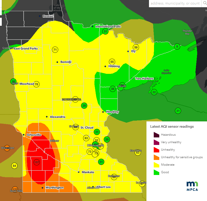
A fresher easterly breeze off the Great Lakes blew in cleaner air Thursday. Our air quality has improved dramatically in the Twin Cities and eastern Minnesota.
Air quality index readings as of this post late Thursday have improved into the good to moderate range across most of Minnesota. A smudge of unhealthy air remains in southwestern Minnesota.
Turn Up Your Support
MPR News helps you turn down the noise and build shared understanding. Turn up your support for this public resource and keep trusted journalism accessible to all.

As of this post time, air quality alerts remain in effect for southwestern Minnesota and Wisconsin. The Twin Cities and most of central and southeast Minnesota have been dropped from the alert area.

The alert zones and times have been changing rapidly this week as conditions change, so please check your area for updated air quality alert information.
The National Oceanic and Atmospheric Administration’s Rapid Refresh models forecast some smoke to swirl around parts of Minnesota Friday. But it looks like most of the smoke will be aloft. Here’s the near-surface smoke output for 10 am Friday.

Air quality at the ground Friday is forecast to be in the moderate range.
Drought expands
Severe drought has returned to parts of central Minnesota this week.
The severe drought zone covers about 2 percent of our state. The area runs from around St. Cloud to the south of Lake Mille Lacs into Pine County. Moderate drought now covers most of central Minnesota, including the Twin Cities.
Here’s the latest map from this week’s U.S. Drought Monitor:

Searching for rain
The past month has been the driest period on record at Minneapolis-St. Paul International Airport. Parts of the Twin Cities have seen more than an inch of rain, but the airport is one of those areas that has seen little rain over the past 30 days.
The past month has been even drier than the infamous drought summer of 1988.
The record dryness is additionally concerning because June is the wettest month of the year on average in Minnesota. The average rainfall for the past 30 days in the Twin Cities is 4.26 inches. Our crops. lawns, vegetation, lakes, and rivers depend on abundant rainfall this time of year.
The latest forecast models suggest scattered rain and thunderstorms this weekend. But coverage looks spotty again.
NOAA’s Global Forecast System model loop for this weekend shows the trend:

The European Centre for Medium-Range Weather Forecasts model put out spotty rainfall once again through the weekend. The best chance for a soaking rainfall favors western and north-central Minnesota.

Stay tuned.


