Steamy Independence Day with potential severe storms
Tuesday will again be near 90 for the Twin Cities

Go Deeper.
Create an account or log in to save stories.
Like this?
Thanks for liking this story! We have added it to a list of your favorite stories.
Updated 12:00 p.m.
Left over morning thunderstorm and shower activity will continue to diminish. Clouds will partially clear making for a steamy afternoon Tuesday. More storms will develop in southern Minnesota that could become severe.
Cold front is focus for thunderstorms Tuesday
Showers and thunderstorms that were left over from activity that developed in South Dakota Monday night continue to push east and will diminish rapidly midday Tuesday. We’ll see partial clearing allowing things to become steamy in southern Minnesota for the afternoon. The morning showers and clouds may prevent most from hitting quite 90 but it will still be very warm and muggy.

Storms will redevelop in the late afternoon and evening hours, especially in areas that largely missed the morning thunderstorms.

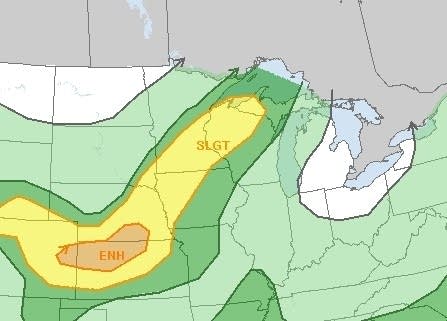
There’s a slight risk (level 2 out of 5) for severe storms across much of central and southern Minnesota into western Wisconsin. The primary threats are large hail and some damaging wind gusts in some storms, especially with the late afternoon storms.
Turn Up Your Support
MPR News helps you turn down the noise and build shared understanding. Turn up your support for this public resource and keep trusted journalism accessible to all.

There’s a question as to how far north severe storms could develop however due to the morning thunderstorms and cloud cover. The highest energy forecast for strong storms looks poised to be mainly across southern Minnesota due to the morning showers in central Minnesota.

Because winds aloft are relatively light, storms will be slow moving producing potentially locally heavy rainfall amounts. There’s a slight risk of excessive rainfall.

Temperatures drop behind the cold front and storms into the 70s and 60s for highs Wednesday.

We’re back to seasonable levels; 80s and 70s by Friday with another chance of thunder by Saturday.


