

Severe storm risk Wednesday; significant smoke event possible Thursday
Highest storm risk across northeast Minnesota Wednesday
Go Deeper.
Create an account or log in to save stories.
Like this?
Thanks for liking this story! We have added it to a list of your favorite stories.
Here we go again.
Our next cold front will spark some potentially severe storms Wednesday and drive another smoke wave into Minnesota Thursday.
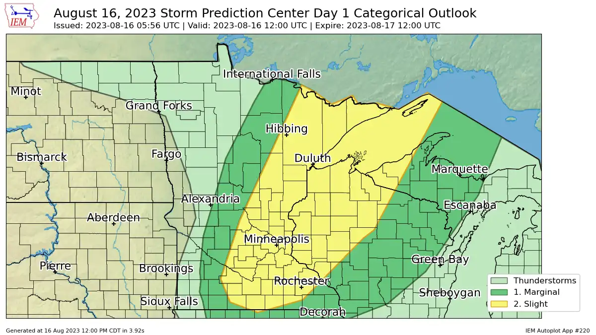
NOAA’s Storm Prediction Center lays out a slight risk (level 2 of 5) for most of central and eastern Minnesota through Wednesday evening (map above).
Storms will develop across northern Minnesota through Wednesday afternoon. Most of the short-range forecast models suggest storms will be slower to develop across the Twin Cities area, and some show storms waiting to develop until after the front passes the Twin Cities around 8 to 9 p.m. Wednesday evening. So we could see storms develop near the Twin Cities, or just southeast of the Twin Cities depending on timing.
Turn Up Your Support
MPR News helps you turn down the noise and build shared understanding. Turn up your support for this public resource and keep trusted journalism accessible to all.
NOAA’s NAM 3 km model is typical of most forecast models that show a line of storms across northeast Minnesota this afternoon, with storms firing on the southeast edge of the Twin Cities around 8 to 9 p.m. Wednesday evening. The forecast model loop below runs between 4 and 10 p.m. Wednesday.

Here’s the convective outlook discussion for our region from NOAA.
...MN/WI/Western Upper MI... Latest surface analysis shows a strong cold front surging southeastward across ND. Southerly low-level winds ahead of the front, along with shallow vertical mixing below a capping inversion, have resulted in a corridor of low-mid 60s dewpoints across much of MN. Strong daytime heating and steep mid-level lapse rates will yield afternoon MLCAPE values around 2500 J/kg. The cap will likely focus thunderstorm development to immediately along or even slightly behind the cold front, but given the strong winds aloft and focused convergence, a few intense bowing structures are expected. Damaging winds and hail appear to be the main threats. Storms will likely persist a few hours after dark and track into parts of northern/central WI and western Upper MI before weakening.
Smoke event Thursday
The next Canadian wildfire smoke wave is thick across Manitoba Wednesday. Air quality readings around Lake Winnipeg are over 300 Wednesday.
NOAA’s RAP model drives a thick plume of near-surface smoke across most of Minnesota Thursday. Here’s the forecast image for 7 p.m. Thursday.

The Minnesota Pollution Control Agency suggests Thursday’s smoke outbreak could be as bad as the worst smoke outbreaks in 2021.
Here’s the forecast discussion.
Wed Aug 16 2023 - The potential for two significant air quality event is unfolding across Minnesota. First - issued an air quality alert for far northcentral and northwestern MN through 10am today. This alert stems from a minor incursion of smoke along the Canadian border. This forecast has Red (Unhealthy for All) for several zones - but the true extent of the Red category will be mainly along the Canadian border in the area. The smoke will gradually retreat this morning. This afternoon severe weather will be possible along a cold front. Following this front will be another smoke incursion. This incursion will have a source region near Lake Winnipeg - which has been sitting in an AQI above 300 for the day. The AQI totals will decrease some as the air moves along the front - but this source region highlights the fact that this next smoke incursion may be impactful enough that the general public will be impacted. For now will keep the air quality alert posted through this morning and will make a call on a new alert when it expires to limit confusion. Of note - the smoke models have so far been underplaying the smoke concentration observed in Canada. Because of that there is some uncertainty on how high concentrations may be in MN. For now made the forecast Thursday easy with Red (Unhealthy for All) in the forecast across the northern half of MN with Orange (Unhealthy for Sensitive Groups) across the rest of MN excluding the southwest corner. Smoke will impact all but the very southwestern part of MN so the forecast there remains in Yellow (Moderate). This was done to indicate the possibility of significant smoke concentrations - ones that may rival what was observed in July/August 2021 here in Minnesota. This situation will continue to be very closely monitored.
Expect unhealthy air quality as the smoke expands across Minnesota Thursday.