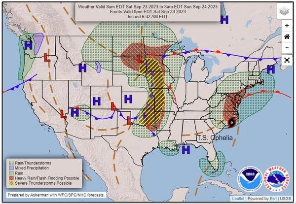
Showers and thunderstorms continue; isolated severe possible south and central
Go Deeper.
Create an account or log in to save stories.
Like this?
Thanks for liking this story! We have added it to a list of your favorite stories.
A weather map that looks more like April than late September has been launching showers and intensifying thunderstorms across Minnesota for Saturday.

A powerful storm system is tapping into rather high dew points and will dump quite a bit of heavy rain around the state well into Saturday night. The drought will continue, so we’ll take any rain we can get.
Along with the many thunderstorms will come the chance of severe weather, especially in southwestern Minnesota where the sun has been able to break through at times.

Twin Cities storms
Turn Up Your Support
MPR News helps you turn down the noise and build shared understanding. Turn up your support for this public resource and keep trusted journalism accessible to all.
Rain reached the Twin Cities by about 5 p.m. on Saturday and will continue for several hours.

Thunderstorms will become embedded in the rain area. Heavy rain is likely. Isolated severe storms with damaging wind and hail are possible.
Scattered showers and thunderstorms will linger into Sunday and Monday, but with no risk of severe weather.
Meaningful rain likely
When all the rainfall reports through Monday come in, it looks like most of Minnesota and western Wisconsin will have been blessed with at least 1 to 2 inches of needed rain. Some spots with repeated rains could easily measure in the 2- to 4-inch range. Forecasting rain in a drought is risky, though, so hedge your bets.
Afternoon temperatures will be about seasonable on Sunday and Monday, with highs in the 60s for much the state to the low 70s in the south and Twin Cities.
Turning dry for a few days beginning Tuesday
Dry weather will arrive on Tuesday and bring several warm, pleasant days. High temperatures will run warmer than normal as we close out September.


