

Scattered rain showers with wind, cold, snow coming; latest drought update
Snow will fall in NW Minnesota into Friday

Go Deeper.
Create an account or log in to save stories.
Like this?
Thanks for liking this story! We have added it to a list of your favorite stories.
Scattered rain showers are back in Minnesota with snow falling in northwestern Minnesota Thursday. Temps drop Friday with winds increasing. Snow will fall in southern Minnesota Saturday.
Rain and snow divide Thursday
Winter weather advisories are posted for northwest Minnesota through 1 p.m. Friday where snow will fall into Friday, farther south it’s rain for now.

We had more rain showers push through much of Minnesota overnight Wednesday night into early Thursday. Those showers will continue to push east.
Showers will be more widely scattered during the day Thursday with more rain developing heading into the evening and overnight, especially in northern Minnesota.
Turn Up Your Support
MPR News helps you turn down the noise and build shared understanding. Turn up your support for this public resource and keep trusted journalism accessible to all.

The precipitation has been and will continue to fall as snow in northwest Minnesota. Traffic cameras show snow covering the ground from Hallock to St. Vincent in the state’s northwest corner. Several inches of snow can be expected in those areas through Friday.

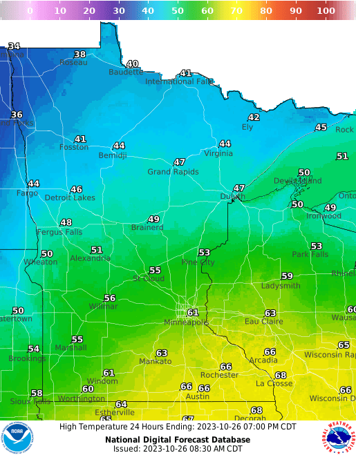
These big differences are being driven by a huge temperature contrast. Highs will range from just the mid-30s in the northwest to upper 60s in southeastern Minnesota Thursday.
Cold, wind and snow push in
Get ready for the winds to howl as cold air dives across the state into Friday. Winds will increase in northwestern Minnesota Thursday afternoon and statewide by Friday morning. Gusts will be as high as 30 to 40 mph from the northwest.

Temperatures will drop Friday through the day from the 50s into the 40s and continue to fall into the 30s and below freezing overnight Friday night.

Saturday and Sunday will be cold with highs in the 30s and even just upper 20s in northwest Minnesota. This cold will set the stage for the next system which will bring snow showers to southern Minnesota Saturday.

We could see some snowfall of up to 1 or even 2 inches in parts of southern Minnesota Saturday afternoon into Saturday night.

Latest drought update
The drought monitor is largely unchanged from last week — 54 percent of Minnesota is still in at least moderate drought down just a few points from a week ago.

The data in the latest drought monitor does not include rainfall we’ve seen since early Tuesday. Since Monday night we’ve seen more than 2 inches of new rainfall in the Twin Cities that will be reflected in next week’s drought monitor update.