

A shot of rain into Saturday morning; Sunday looks glorious
Bright sun and highs near 70 with light winds Sunday
Go Deeper.
Create an account or log in to save stories.
Like this?
Thanks for liking this story! We have added it to a list of your favorite stories.
Clear the calendar for Sunday, Minnesota. Bright blue sky, warm sun, mild temperatures and a recently rare day with lighter wind are ahead Sunday. But first, it’s another shot of rain for many of us.
Our next low-pressure wave crosses Minnesota on Saturday morning. Scattered rain and some thunderstorms will cross our region through Saturday morning, The steadiest rain will fall in the Twin Cities between about 6 and 10 a.m. Saturday. Showers will fade in the afternoon.
The National Oceanic and Atmospheric Administration’s NAM 3 km model below shows the likely progression of rain through Saturday midday.

Temperatures will hover mostly in the 50s on Saturday. Overall rainfall totals with this system will be less than some of our recently prolific storms.
Turn Up Your Support
MPR News helps you turn down the noise and build shared understanding. Turn up your support for this public resource and keep trusted journalism accessible to all.
Most of central Minnesota will pick up less than three-tenths of an inch on Saturday, but many areas south of the Twin Cities toward the Iowa border will pick up one-half inch or more.
Here’s the European Centre for Medium-Range Weather Forecasts model precipitation output through Saturday:

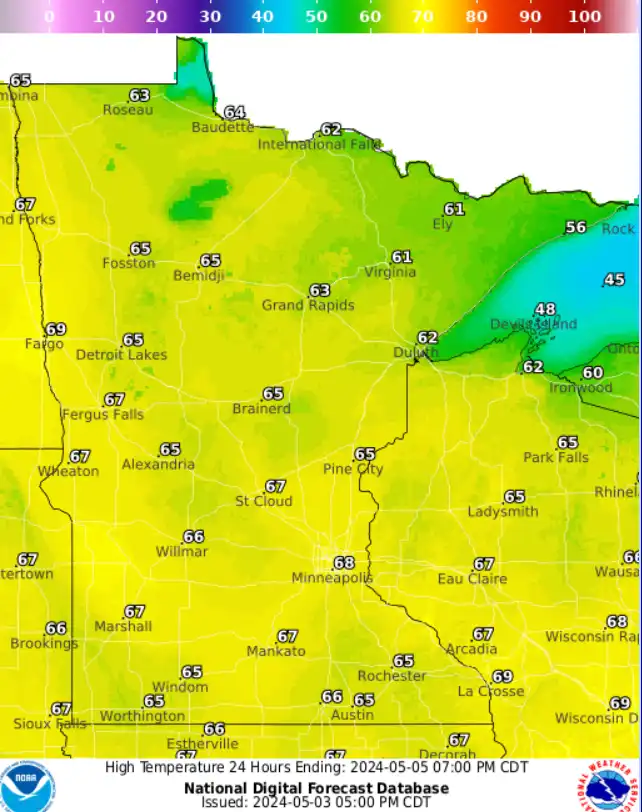
Sunday brings the banner day of the weekend. Look for plenty of sunshine and high temperatures in the upper 60s to near 70 degrees across the south with 60s north.
Monday brings another warm spring day before the next rain system brings more showers Monday night and Tuesday.

The very early look at Mother’s Day and fishing opener weekend favors mainly dry weather with highs probably in the 60s, with a few 70s possible.
Stay tuned.