Spotty showers possible; windy and cold Sunday
Highs in the 50s for Sunday with gusty winds

Go Deeper.
Create an account or log in to save stories.
Like this?
Thanks for liking this story! We have added it to a list of your favorite stories.
Reinforcing cold air will arrive Saturday night, cooling us down for several days. Winds will pick up behind the front, with gusts reaching up to 35 mph. Isolated to scattered rain showers possible this weekend.
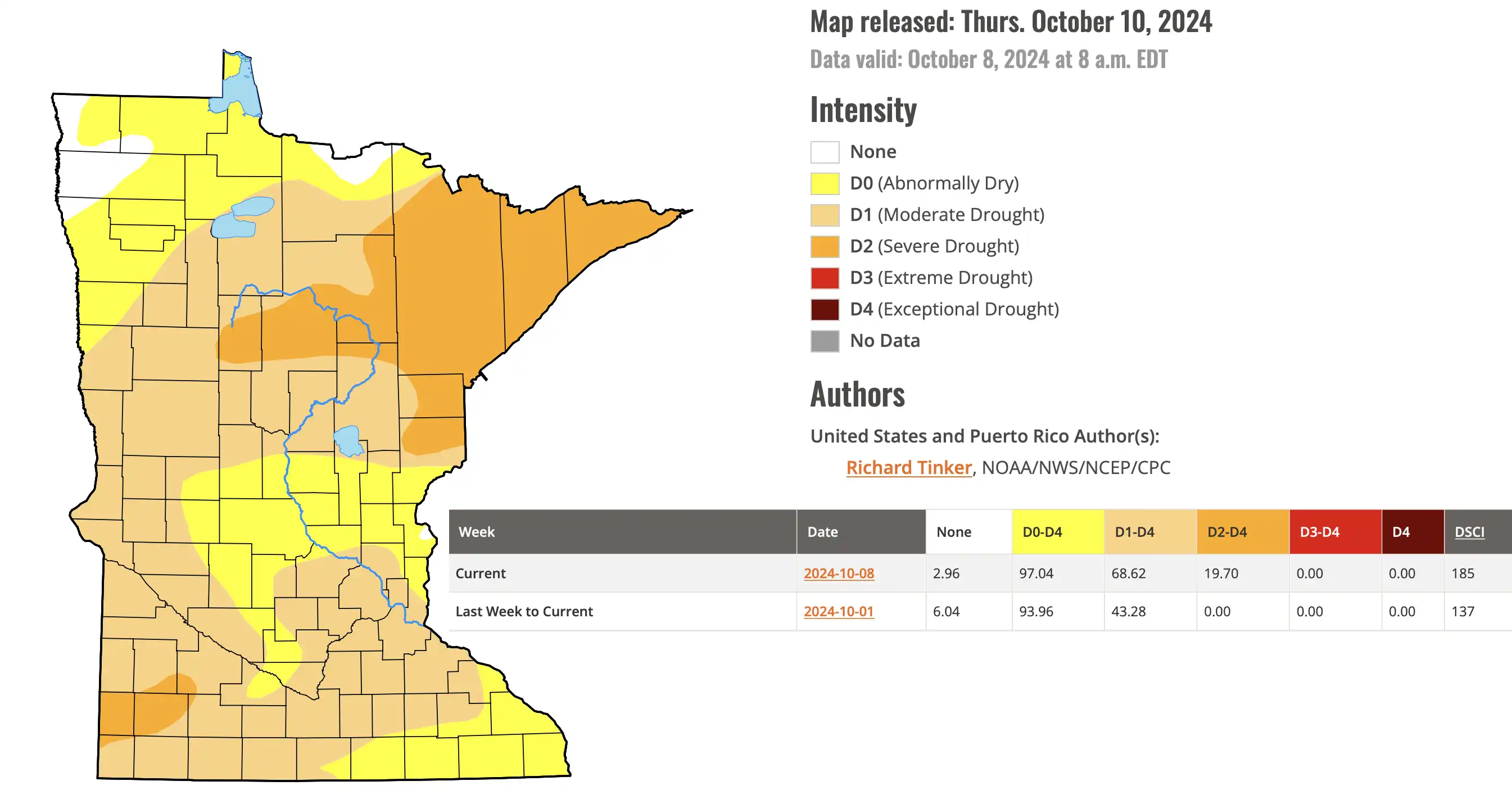
Was that rain?!?
Earlier on Saturday, some rainfall was recorded in the central and northern parts of the state.
Fertile 0.37 inches
Park Rapids 0.23 inches
Bemidji 0.15 inches
Many areas received several hundredths of an inch of rain. It’s not much, but at least it’s something.
Turn Up Your Support
MPR News helps you turn down the noise and build shared understanding. Turn up your support for this public resource and keep trusted journalism accessible to all.

Another chance for isolated to scattered showers is expected late Saturday into Sunday as an upper-level trough moves southward.

This disturbance will also bring breezy northwesterly winds with gusts exceeding 35 mph, along with cooler Canadian air.
Lows tonight are expected to fall into the lower to mid-40s across central and southern Minnesota, while northern areas will see temperatures in the upper 30s to around 40 degrees. However, the breezy winds will add a chill to the air.

End to our growing season ahead
Several rounds of cool Canadian air this weekend will lead to below-average temperatures from Sunday to Tuesday. The average high is 60°F for the Twin Cities, 55°F for Duluth, 53°F for International Falls, and 60°F for Rochester.

With clearing skies and calming winds, overnight temperatures into Tuesday are expected to dip to some of the coolest readings we’ve experienced since April 20th for the Twin Cities.

Some areas of Minnesota have already recorded freezing temperatures at 32 degrees. Northeastern Minnesota saw freezing temperatures in September and early October.

Warm and wet conditions on the way
The cooler airmass will be short-lived, as temperatures in the 60s and 70s are expected to return by Wednesday and Thursday. A significant shift in our weather pattern will lead to warmer southerly flow, and a more unstable weather pattern. Current forecast models suggest widespread, significant rainfall may occur by next weekend. Given the widespread drought conditions in the state, any precipitation beyond just sprinkles will be welcomed.