

Decreasing clouds Wednesday and continued mild
Snow showers Wednesday night in NE Minnesota

Go Deeper.
Create an account or log in to save stories.
Like this?
Thanks for liking this story! We have added it to a list of your favorite stories.
The mild stretch continues Wednesday and all week. Another disturbance will bring snow showers to northeastern Minnesota Wednesday night.
Mild Wednesday, evening snow showers north
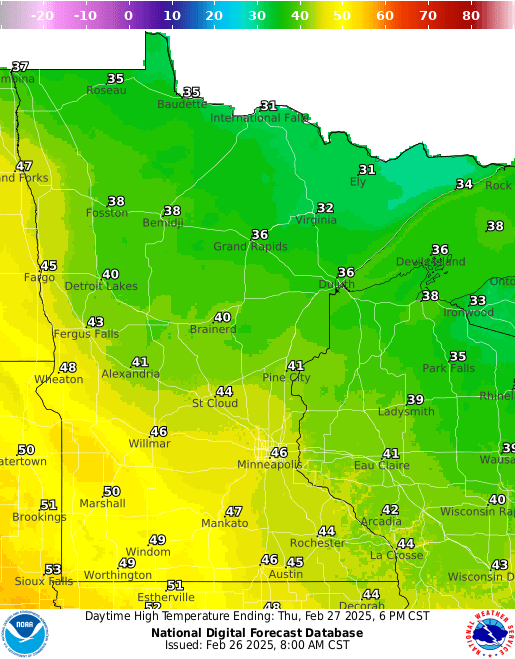
Temperatures will continue the mild streak Wednesday. Highs will be in the 40s to low 50s across southern Minnesota and in the 30s north. It will get a bit breezy with west winds at 10 to 15 mph, closer to 20 mph west. Clouds will decrease through the day.

Snow showers develop overnight into Thursday for northeastern Minnesota with the next disturbance. Southern Minnesota will stay largely dry. Another disturbance will affect, again mainly northern Minnesota Friday with more snow showers.

A coating to as much as an inch or two could fall in northeastern Minnesota into early Thursday morning.
Turn Up Your Support
MPR News helps you turn down the noise and build shared understanding. Turn up your support for this public resource and keep trusted journalism accessible to all.

Overnight temperatures Wednesday night will drop below freezing for northern Minnesota to near freezing or slightly above in southern Minnesota.

Thursday and Friday will continue to be mild ahead of the next disturbance moving in Friday.
The Friday snowfall could be more substantial for northern Minnesota. Several inches of wet snow is possible Friday into Friday night for primarily northeastern Minnesota.

It will then be briefly cooler Saturday with highs in the 30s across southern Minnesota with 20s with even some upper teens in northern Minnesota.
We warm up again quickly into early next week.