

Cold high pressure brings chilly sunshine Monday
Temperatures will climb throughout the week

Go Deeper.
Create an account or log in to save stories.
Like this?
Thanks for liking this story! We have added it to a list of your favorite stories.
It’s a chilly start to the week as cold high pressure settles in. Temperatures will warm through the week with a chance for some showers Wednesday into Thursday.
Chilly start to the week but much warmer by the weekend
We’ll have lots of sunshine Monday but it will be chilly as a chunk of cold high pressure settles into Minnesota. Highs will be mostly in the 30s with a few 40-degree readings in southern Minnesota. These temperatures are 10 to 15 degrees below normal.

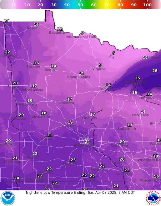
Expect another cold night under clear skies. Lows will drop into the 20s, teens and even single digits in parts of northeastern Minnesota.
Temperatures already jump upward Tuesday with highs in the 50s in southwestern Minnesota and 40s for most of the rest of the state with more sunshine.
Turn Up Your Support
MPR News helps you turn down the noise and build shared understanding. Turn up your support for this public resource and keep trusted journalism accessible to all.

A relatively weak disturbance moves through Wednesday into Thursday, touching off some spotty rain showers. Some snow could mix in with some showers in northern Minnesota.

Precipitation amounts should be light with most of the state seeing one-tenth of an inch of precipitation or less.

Spring is back by the end of the week with highs in the 60s and 50s to potentially near 70 degrees by the weekend.

The six to 10-day temperature and precipitation outlook calls for warmer-than-normal temperatures this weekend into next week and drier-than-normal weather.
