Gravity waves drove weekend storms; severe risk today

Go Deeper.
Create an account or log in to save stories.
Like this?
Thanks for liking this story! We have added it to a list of your favorite stories.
A relatively rare and unpredictable weather phenomenon called gravity waves may have been the culprit for the severe weekend storms that pounded the Twin Cities.
Statewide: Snow, icebergs, deluge: 5 weirdest days this spring
Saturday's unusual wave-like cloud photos are a tip of for the unusual "undular bores" that focused the sustained severe wind gusts.
My MPR News colleague Jeffrey Thompson captured this telltale image Saturday as the storms rolled through.
Turn Up Your Support
MPR News helps you turn down the noise and build shared understanding. Turn up your support for this public resource and keep trusted journalism accessible to all.
Sustained winds of 50 miles per hour and gusts to near 70 mph lasted more than half an hour in some parts of the Twin Cities Saturday morning and midday as the gravity wave driven storms rolled rippled through the atmosphere overhead.
3 E Richfield [Hennepin Co, MN] ASOS reports NON-TSTM WND GST of 68.00 MPH at 12:56 PM CDT -- ASOS STATION MINNEAPOLIS-ST PAUL INTL AP /MSP/
Scattered wind damage was reported around the metro as the storms rolled through.
Gravity waves are still an emerging area of research in meteorology.
Meteorologists still don't fully understand just how they tap into storms, and duct severe winds to ground level. The best way I can describe these rare events is to think of throwing a big rock into a calm lake, and watching the pressure waves and ripples flow out from the splash. These pressure waves roll out, as the force of gravity tries to return the lake to it's natural calm state.
Here's a good time lapse of a gravity wave rolling through Iowa.
Sailors in danger
I tweeted this storm reports Saturday morning as the storms rolled through the west metro and high winds ripped through the Weather Lab near Lake Minnetonka.
What I didn't know at the time was that several of my closest friends were caught on the lake in the storm, literally clinging to their capsized or swamped sailboats in the still hypothermic water.
Some of them battled 60 to 70 mph winds and 4-5 foot waves for up to 45 minutes as the storms raged. Their boats were literally washed up, and chewed up on the rocky shore in Orono just as the race got started Saturday morning.
If you watched local news Saturday you saw my good friends and sailing buddies Henk and Hans Vroege and Mark Werley describe their harrowing, and literally life-threatening experiences. Henk and his son Hans described their ordeal to me personally in our families' Father's Day (power) boat ride Sunday afternoon.
Here is their story via WCCO-TV.


Thankfully these experienced sailors are well trained to deal with severe winds, or this situation might have turned out much differently.
Seas were much quieter on the "no wake lake" called Minnetonka for the boat ride Sunday evening, and the sunset was a nice reward.

The record high water on Tonka is affecting local business there. My son Luke works a summer job at a local marina on the lake. He reports gas sales for the Marina, and tips for employees are way down. The are also cutting back on summer hours. The dock guy at Bayside in Excelsior last evening says his tips are way down as well as fewer boats make the trip on the no wake lake. The economic ripple effect from high water on Lake Minnetonka alone is already in the thousands of dollars, and climbing by the day.
Another weekend deluge
As expected, the storms also produced yet another weekend of flooding rains across Minnesota. Southwest Minnesota got pounded with 5 to 7 inch rainfall this past weekend. That's literally six weeks worth of rain in less than 36 hours. Most of central and southern Minnesota picked up 2 to 4inches.
Here's the rainfall map from Twin Cities National Weather Service.

Severe threat returns today
The atmosphere is already reloading as the next storm rolls in. Here's the map sequence, as more waves of wet weather aim for Minnesota this week.

The National Oceanic and Atmospheric Administration's Storm Prediction Center has southern Minnesota under a slight risk for severe storms again today. A moderate risk runs up to the Interstate 90 corridor and covers much of Iowa.

NOAA isn't pulling any punches about the risk today, including a few "significant tornadoes" in southern Minnesota.
THE STORMS THAT DO FORM OVER THE ERN NEB AREA SHOULD MERGE WITH WAA ACTIVITY DEVELOPING ESE FROM SE SD BY EVE. THIS SHOULD RESULT IN THE DEVELOPMENT OF A SIZABLE MCS THAT SHOULD THEN TRACK GENERALLY E OR ESE ACROSS PARTS OF IA...SRN MN AND...LATER TNGT/EARLY TUE...WI. EMBEDDED BOWING SEGMENTS AND SUPERCELLS IN THE CONVECTIVE SYSTEM WILL POSE A CONTINUING RISK FOR SVR WIND AND HAIL.
Here are the percentages for severe risk in the severe zone today.

Severe storms will likely sweep through southern Minnesota anytime this afternoon, but the risk will increase dramatically for the Twin Cities late this afternoon and evening. Here's a look at NOAA's High Resolution Rapid Refresh "future radar" which shows a possible bow echo with a damaging wind signature blowing into the metro between 7 pm and 9 pm tonight.

Bottom line: Keep aware for watches and warnings later this afternoon and evening across southern Minnesota, including the Twin Cities metro area.
June monsoon continues
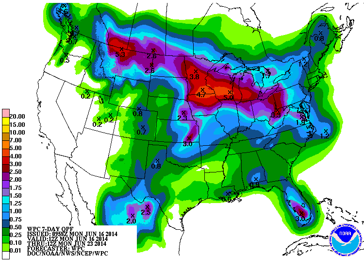
Low pressure waves continue this week. Yes, another 2 to 5 inches of rain could fall by Friday evening. Keep those gutters clean this week.


