

Winter interrupted: Longest January thaw in 25 years?
Go Deeper.
Create an account or log in to save stories.
Like this?
Thanks for liking this story! We have added it to a list of your favorite stories.
Welcome to January thaw time in Minnesota.
January thaw - In the United States, a period of mild weather popularly supposed to recur each year, in later January; most pronounced in the Northeast and, to a lesser extent, the Midwest. - AMS Glossary of Meteorology.

January thaws may not occur every year in Minnesota. But most years we see a spike in temperatures with several days above the thawing point in mid to late January.
Turn Up Your Support
MPR News helps you turn down the noise and build shared understanding. Turn up your support for this public resource and keep trusted journalism accessible to all.
This year's January thaw looks like a doozy. We could see 9 consecutive days above the thawing point, and several days with highs topping the 40-degree mark. Overnight minimum temperatures may hold just above freezing in the Twin Cities this weekend.
Bye, bye snow cover.

Longest January thaw in 25 years?
If this January thaw reaches 9 days, it will be the longest since 1992 when the Twin Cities saw 12 straight thaw days in 1992.
Pacific breeze
Meteorologists watch the 500-millibar flow across North America closely in winter. When it roars from the Yukon southeast into Minnesota, we know it's going to be frigid. When the upper winds blow from Seattle and Portland? Milder Pacific breezes kick in. Time to grab a latte.

Thaw, freeze, repeat
We'll see some rapid freeze thaw cycles the next few days. Temps shoot above freezing during the day, then watch out for refreeze (and icy conditions underfoot) at night. Temps may hold above the freezing mark overnight in the Twin Cities this weekend. Watch as the temperature maps pulse from blue, to mostly green over the next week.
It's going to feel like spring just a few hours drive south. Temps in the 50s as close as Des Moines and Chicago?

Bye-bye snow
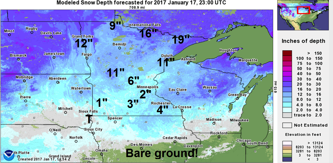
We can say goodbye to snow cover across most of southern Minnesota in the next few days. Right now we're clinging to just 2" at MSP Airport, and that will likely be gone by Friday. Deeper snow is still there around International Falls and the BWCA with 16" to 19".
Here's a look at current snow cover across Minnesota.
Mild through January?
Looking at the longer range maps, temperatures are trending warmer than average overall for the last half of January. We may cool closer to, but still slightly above average next week.

There are hints of a potentially sloppy rain to snow event toward the middle of next week.
It's really early to put a lot of credence in this yet, but the notion of a low tracking from Iowa through Wisconsin has been popping up now in multiple model runs. The Euro also has a rain to snow scenario in for the middle of next week.
Here's NOAA's GFS model for next week.

Stay tuned.
